


C'est superbe! Merci Jeannot pour toutes ces belles images 
+7
Vector
audac
patrick1956
massemini
eolien
Poncho (Admin)
Jeannot
11 participants
L'espace par l'image

Jeannot- Whisky Quebec
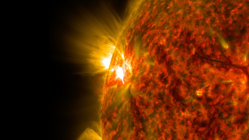
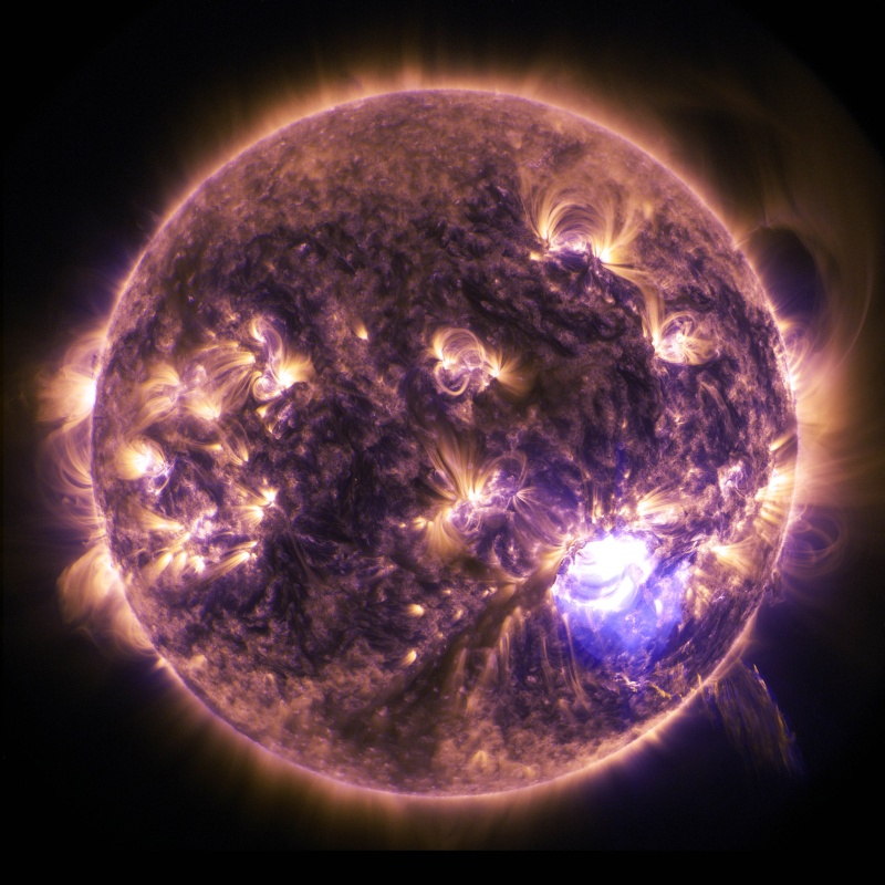
Belle éruption solaire (5 novembre 2014)
La lecture du document nous permet de connaitre la classification de ces éruptions.
http://www.nasa.gov/content/nasas-solar-dynamics-observatory-captures-intense-space-weather/#.VFy2FWeFAVh
La lecture du document nous permet de connaitre la classification de ces éruptions.
NASA's Solar Dynamics Observatory Captures Intense Space Weather
An active region on the sun emitted a mid-level solar flare, peaking at 4:47 a.m. EST on Nov. 5, 2014. This is the second mid-level flare from the same active region, labeled AR 12205, which rotated over the left limb of the sun on Nov. 3. The image was captured by NASA's Solar Dynamics Observatory (SDO) in extreme ultraviolet light that was colorized in red and gold.
Solar flares are powerful bursts of radiation. Harmful radiation from a flare cannot pass through Earth's atmosphere to physically affect humans on the ground, however -- when intense enough -- they can disturb the atmosphere in the layer where GPS and communications signals travel.
This flare is classified as an M7.9-class flare. M-class flares are a tenth the size of the most intense flares, the X-class flares. The number provides more information about its strength. An M2 is twice as intense as an M1, an M3 is three times as intense, etc.
http://www.nasa.gov/content/nasas-solar-dynamics-observatory-captures-intense-space-weather/#.VFy2FWeFAVh
Invité- Invité
C'est aujourd'hui que Rosetta largue son atterrisseur Philae sur la comète 67P/Churyumov-Gerasimenko. La séquence débutera à 9h30 heure de Paris, avec la séparation du module de descente.
Voici le programme:
Journée d'atterrissage de Philae le 12 novembre (en heure de Paris) :
Pour ceux qui le souhaitent, le CNES propose de suivre l’événement en direct avec 4 flux vidéos simultanés.
Le site du Cnes:
http://www.cnes.fr/web/CNES-fr/11542-gp-en-direct-atterrissage-de-philae.php
Le lien Youtube:
https://www.youtube.com/watch?v=Z2DRt-B3DWo
Le direct débutera à 15h30 le mercredi 12 novembre
Nicolas
Voici le programme:
Journée d'atterrissage de Philae le 12 novembre (en heure de Paris) :
- 9h30 : séparation et début de la descente de Philae ; confirmation à 10h03
- 9h45 : ouverture du train d'atterrissage de Philae
- 15h30 : début de la retransmission web en vidéos multi-flux
- 15h54 : début des prises de vue du site d'atterrissage Agilkia par la caméra ROLIS
- 16h34 : contact avec la surface de la comète 67P/Churyumov-Gerasimenko
- 17h (+ ou - 15 min) : confirmation de l'atterrissage par le centre de contrôle de Philae
- 19h : réception du panorama du paysage autour de Philae
Pour ceux qui le souhaitent, le CNES propose de suivre l’événement en direct avec 4 flux vidéos simultanés.
Le site du Cnes:
http://www.cnes.fr/web/CNES-fr/11542-gp-en-direct-atterrissage-de-philae.php
Le lien Youtube:
https://www.youtube.com/watch?v=Z2DRt-B3DWo
Le direct débutera à 15h30 le mercredi 12 novembre
Nicolas

Invité- Invité
Et voila, c'est fait, l’atterrissage s'est bien déroulé, premières images dans une heure

Jeannot- Whisky Quebec
Super événement...

Poncho (Admin)- Whisky Charlie
C est que je me dit que la vieille Europe elle est encore bien verte et jeune.
Super super...
Super super...
_________________
@avia.poncho

Paul- Whisky Quebec
l'album photo
https://flic.kr/s/aHsjNrJ7wt
https://flic.kr/s/aHsjNrJ7wt

Beochien- Whisky Charlie
La mini fusée d'appui n'a pas marché !
Les 2 harpons d'ancrage n'ont pas fonctionné comme voulu ... ?? Où pas accrochés !
Les 3 pieds/tarauds semblent tourner dans de la guimauve ...
La sonde est instable et pas amarrée, pour l'instant, avec des giros qui tournent encore, c'est d'ailleurs plus ennuyeux une foi au sol ... car la comète, elle tourne !
Donc, pas de photos exploitables pour l'instant !
Entendu que le poids de la sonde, serait de l'ordre du (Ou de qq ) grammes, pas beaucoup de G là bas !
Ça pourrait être difficile de forer, dans l'état des choses ! !
Patience ... les transmissions fonctionnent !
Invité- Invité
En fait la sonde a rebondi à l’atterrissage, ce qui explique son instabilité des premières heures puisqu'il lui a fallu 2 heures pour retomber, a l'heure actuelle elle est un peu plus loin que son premier point de chute et semble stable. Le premier panorama est flou, a cause des mouvements de la sonde durant le rebond, un autre sera pris a 5h GMT. Voici la zone ou elle a atterri, la caméra Rolis est celle de philae qui a envoyé des images pendant la descente, elle située sous la sonde
https://farm6.staticflickr.com/5609/15589900568_d6c13841a7_o.png
https://farm6.staticflickr.com/5609/15589900568_d6c13841a7_o.png

massemini- Whisky Quebec
Heureusement qu' il y a une infime gravité (même si elle est considérée comme inexistante), si non, Philae ne serait pas retombée.
Avec sa faible vitesse "d' approche" (1m/s), elle n' a pu que remonter à une vitesse inférieure/nettement inférieure?
Question à 100 balles:
De combien de m est-elle remontée pour que ce" mini-vol supplémentaire" dure 2 H?......
Avec sa faible vitesse "d' approche" (1m/s), elle n' a pu que remonter à une vitesse inférieure/nettement inférieure?
Question à 100 balles:
De combien de m est-elle remontée pour que ce" mini-vol supplémentaire" dure 2 H?......
Paul- Whisky Quebec
voici la première image de Philae sur la comette, on voit une de ses pattes en bas de la photo.
Invité- Invité
Conférence de presse en direct en ce moment même:
http://rosetta.esa.int/
http://rosetta.esa.int/
Poncho (Admin)- Whisky Charlie
Ca a l'air scabreux comme position 
_________________
@avia.poncho
Invité- Invité
Oui, elle a un pied en l'air... Il y a eu 3 atterrissages, en tout! Elle s'est déplacée de plus d'un kilomètre par rapport a son premier atterrissage, le record de distance parcouru par une sonde sur une comète est battu
Invité- Invité
Pour ceux que l'anglais barbe, la conférence est aussi en live sur itélé, en français
http://www.itele.fr/direct
http://www.itele.fr/direct
massemini- Whisky Quebec
http://aviationweek.com/space/despite-difficult-landing-europe-s-comet-chasing-mission-historic
Je ne pensais pas que l' on aurait ces détails
38 cm /sec au 1er rebond, annulé vers 1 km d' altitude; un "zoom" de 2 H
3 cm/sec au 2ème rebond, petit "zoom" de 7 mn.
On ne sait pas si Philae est bien remonté à la verticale ou s' il a subit une déviation, le sol n' étant pas plat.
A moins que l' éloignement de 1 km du 1er poser ait été essentiellemant dû à la rotation de la comète durant 2 H....
Beochien- Whisky Charlie
Bon, une com de Berlin, sur Philae !
QQ infos transmises, avant la veille obligée (Il se ranimera dans qq temps ... quand, on ne sait pas ?)
Des molécules organiques précurseurs de la vie , identifiées, c'est magnifique !
Provenant de la tentative de forage ?
Ils sont tombé sur du "Dur" à 20 cm, la moitié de l'espéré !
Peut être aussi le manque d'énergie pour poursuivre ...
Possible aussi, que des molécules provenant des nuages de poussière soulevés lors des rebonds ont apporté des éléments à analyser, c'était prévu dans le process ...
http://www.firstpost.com/world/comet-team-detects-organic-molecules-basis-of-life-on-earth-1809645.html
Beochien- Whisky Charlie
Etonnant sur Space.com !
Le Philae, pas si perdu que ça ... ils ont photographie son re-bond et ses empreintes bravo pour les images !
http://www.space.com/27788-philae-comet-landing-bounce-photos.html?cmpid=558605

Le Philae, pas si perdu que ça ... ils ont photographie son re-bond et ses empreintes bravo pour les images !
http://www.space.com/27788-philae-comet-landing-bounce-photos.html?cmpid=558605
Jeannot- Whisky Quebec
Maintenant que notre petit Philae est en hibernation reprenons notre série
Tableau composite
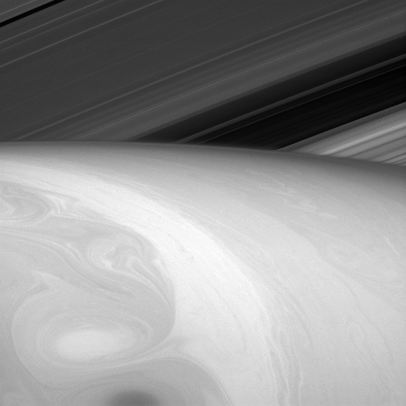
Ce qui ressemble à la surface de Saturne est en fait la haut de la couche supérieure de nuages.
http://www.nasa.gov/jpl/cassini/pia18290/#.VGzAsGeFAVh
Tableau composite
Mixing Paints
Nature is an artist, and this time she seems to have let her paints swirl together a bit.
What the viewer might perceive to be Saturn's surface is really just the tops of its uppermost cloud layers. Everything we see is the result of fluid dynamics. Astronomers study Saturn's cloud dynamics in part to test and improve our understanding of fluid flows. Hopefully, what we learn will be useful for understanding our own atmosphere and that of other planetary bodies.
This view looks toward the sunlit side of the rings from about 25 degrees above the ringplane. The image was taken in red light with the Cassini spacecraft narrow-angle camera on Aug. 23, 2014.
The view was acquired at a distance of approximately 1.1 million miles (1.8 million kilometers) from Saturn and at a Sun-Saturn-spacecraft, or phase, angle of 127 degrees. Image scale is 7 miles (11 kilometers) per pixel.
The Cassini-Huygens mission is a cooperative project of NASA, the European Space Agency and the Italian Space Agency. The Jet Propulsion Laboratory, a division of the California Institute of Technology in Pasadena, manages the mission for NASA's Science Mission Directorate, Washington, D.C. The Cassini orbiter and its two onboard cameras were designed, developed and assembled at JPL. The imaging operations center is based at the Space Science Institute in Boulder, Colo.
For more information about the Cassini-Huygens mission visit http://www.nasa.gov/cassini and http://saturn.jpl.nasa.gov . The Cassini imaging team homepage is at http://ciclops.org .
Credit: NASA/JPL-Caltech/Space Science Institute
Ce qui ressemble à la surface de Saturne est en fait la haut de la couche supérieure de nuages.
http://www.nasa.gov/jpl/cassini/pia18290/#.VGzAsGeFAVh
Jeannot- Whisky Quebec
Décollage de Souyouz TMA-15M ce 24 novembre

http://www.nasa.gov/content/expedition-42-launches-to-the-international-space-station/#.VHNZPmeFAVh
Expedition 42 Launches to the International Space Station
The Soyuz TMA-15M rocket launches from the Baikonur Cosmodrome in Kazakhstan on Monday, Nov. 24, 2014 as seen in this long exposure carrying Expedition 42 Soyuz Commander Anton Shkaplerov of the Russian Federal Space Agency (Roscosmos), Flight Engineer Terry Virts of NASA, and Flight Engineer Samantha Cristoforetti of the European Space Agency (ESA) into orbit to begin their five and a half month mission on the International Space Station.
Image Credit: NASA/Aubrey Gemignani
http://www.nasa.gov/content/expedition-42-launches-to-the-international-space-station/#.VHNZPmeFAVh
Poncho (Admin)- Whisky Charlie
Celle là elle marche toujours et encore !
_________________
@avia.poncho
Jeannot- Whisky Quebec
L'étonnante surface gelée de Europa
[url defaultattr=]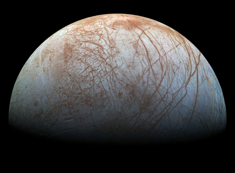 [/url]
http://www.nasa.gov/jpl/europas-stunning-surface/#.VHXfwmeFAVh
[url defaultattr=]
[/url]La surface de Europa, satellite de Jupiter, est gelée. Des fissures et des crêtes sillonnent la surface avec des zones plus complexes où la glace de surface a été c&ssée puis recongelée.
Les différentes couleurs correspondent à des différences géologiques. Par exemple, les zones qui apparaissent en blanc ou en bleu contiennent de la glace d'eau relativement pure, tandis que les zones plus brunâtres ou rougeâtre comportent des éléments non-glacés en concentrations plus élevées.
Europa's Stunning Surface
The puzzling, fascinating surface of Jupiter’s icy moon Europa looms large in this newly-reprocessed color view, made from images taken by NASA's Galileo spacecraft in the late 1990s. This is the color view of Europa from Galileo that shows the largest portion of the moon's surface at the highest resolution.
The view was previously released as a mosaic with lower resolution and strongly enhanced color (see PIA02590). To create this new version, the images were assembled into a realistic color view of the surface that approximates how Europa would appear to the human eye.
The scene shows the stunning diversity of Europa’s surface geology. Long, linear cracks and ridges crisscross the surface, interrupted by regions of disrupted terrain where the surface ice crust has been broken up and re-frozen into new patterns.
Color variations across the surface are associated with differences in geologic feature type and location. For example, areas that appear blue or white contain relatively pure water ice, while reddish and brownish areas include non-ice components in higher concentrations. The polar regions, visible at the left and right of this view, are noticeably bluer than the more equatorial latitudes, which look more white. This color variation is thought to be due to differences in ice grain size in the two locations.
Images taken through near-infrared, green and violet filters have been combined to produce this view. The images have been corrected for light scattered outside of the image, to provide a color correction that is calibrated by wavelength. Gaps in the images have been filled with simulated color based on the color of nearby surface areas with similar terrain types.
This global color view consists of images acquired by the Galileo Solid-State Imaging (SSI) experiment on the spacecraft's first and fourteenth orbits through the Jupiter system, in 1995 and 1998, respectively. Image scale is 1 mile (1.6 kilometers) per pixel. North on Europa is at right.
The Galileo mission was managed by NASA's Jet Propulsion Laboratory in Pasadena, California, for the agency's Science Mission Directorate in Washington. JPL is a division of the California Institute of Technology, Pasadena.
Additional information about Galileo and its discoveries is available on the Galileo mission home page at http://solarsystem.nasa.gov/galileo/. More information about Europa is available at http://solarsystem.nasa.gov/europa.
Image Credit: NASA/JPL-Caltech/SETI Institute
http://www.nasa.gov/jpl/europas-stunning-surface/#.VHXfwmeFAVh
Dernière édition par Jeannot le Mer 26 Nov 2014 - 16:54, édité 1 fois
Jeannot- Whisky Quebec
Simulation informatique des champs magnétiques du soleil
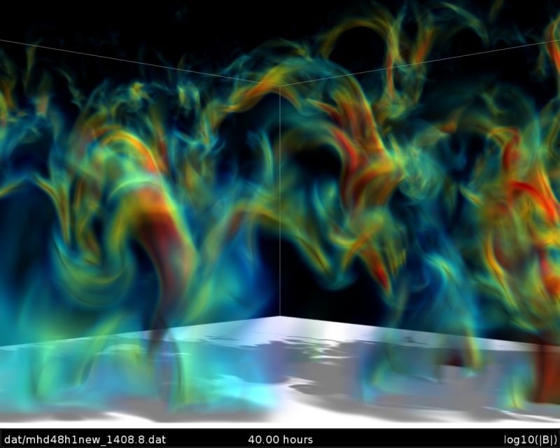
Cette image montre la force des champs magnetiques, depuis faible en bleu à fort en rouge...
Supercomputer Simulation of Magnetic Field Loops on the Sun
Magnetic fields emerging from below the surface of the sun influence the solar wind—a stream of particles that blows continuously from the sun’s atmosphere through the solar system. Researchers at NASA and its university partners are using high-fidelity computer simulations to learn how these magnetic fields emerge, heat the sun’s outer atmosphere and produce sunspots and flares.
This visualization shows magnetic field loops in a portion of the sun, with colors representing magnetic field strength from weak (blue) to strong (red). The simulation was run on the Pleiades supercomputer at the NASA Advanced Supercomputing facility at NASA's Ames Research Center in Moffett Field, California.
The knowledge gained through simulation results like this one help researchers better understand the sun, its variations, and its interactions with Earth and the solar system.
Image Credit: Robert Stein, Michigan State University; Timothy Sandstrom, NASA/Ames
Jeannot- Whisky Quebec
Curiosity met en évidence des formes de dépôts sédimentaires

http://www.nasa.gov/jpl/msl/pia19074/#.VIhzVcnmknh
Sedimentary Signs of a Martian Lakebed
This evenly layered rock photographed by the Mast Camera (Mastcam) on NASA's Curiosity Mars Rover shows a pattern typical of a lake-floor sedimentary deposit not far from where flowing water entered a lake.
The scene combines multiple frames taken with Mastcam's right-eye camera on Aug. 7, 2014, during the 712th Martian day, or sol, of Curiosity's work on Mars. It shows an outcrop at the edge of "Hidden Valley," seen from the valley floor. This view spans about 5 feet (1.5 meters) across in the foreground. The color has been approximately white-balanced to resemble how the scene would appear under daytime lighting conditions on Earth. Figure A is a version with a superimposed scale bar of 50 centimeters (about 20 inches).
This is an example of a thick-laminated, evenly-stratified rock type that forms stratigraphically beneath cross-bedded sandstones regarded as ancient river deposits. These rocks are interpreted to record sedimentation in a lake, as part of or in front of a delta, where plumes of river sediment settled out of the water column and onto the lake floor.
NASA's Jet Propulsion Laboratory, a division of the California Institute of Technology, Pasadena, manages the Mars Science Laboratory Project for NASA's Science Mission Directorate, Washington. JPL designed and built the project's Curiosity rover. Malin Space Science Systems, San Diego, built and operates the rover's Mastcam. For more information about Curiosity, visit http://www.nasa.gov/msl and http://mars.jpl.nasa.gov/msl.
http://www.nasa.gov/jpl/msl/pia19074/#.VIhzVcnmknh
Jeannot- Whisky Quebec
Quelque chose comme cela
http://www.nasa.gov/press/2014/december/nasa-s-curiosity-rover-finds-clues-to-how-water-helped-shape-martian-landscape/#.VIh1Fcnmknh
http://www.nasa.gov/press/2014/december/nasa-s-curiosity-rover-finds-clues-to-how-water-helped-shape-martian-landscape/#.VIh1Fcnmknh
Jeannot- Whisky Quebec
Une belle photo de la Galaxie IC 135

http://www.nasa.gov/content/goddard/hubble-sees-the-beautiful-side-of-ic-335/#.VJ55pchQ
Cette photo prise par Hubble montre la galaxie IC 335 en face de galaxies lointaines . IC 335 fait partie d'un groupe de galaxies contenant trois autres galaxies , et situé à 60 millions d'années-lumière
Hubble Sees the Beautiful Side of Galaxy IC 335
This new NASA/ESA Hubble Space Telescope image shows the galaxy IC 335 in front of a backdrop of distant galaxies. IC 335 is part of a galaxy group containing three other galaxies, and located in the Fornax Galaxy Cluster 60 million light-years away.
As seen in this image, the disk of IC 335 appears edge-on from the vantage point of Earth. This makes it harder for astronomers to classify it, as most of the characteristics of a galaxy’s morphology — the arms of a spiral or the bar across the center — are only visible on its face. Still, the 45 000 light-year-long galaxy could be classified as an S0 type.
These lenticular galaxies are an intermediate state in galaxy morphological classification schemes between true spiral and elliptical galaxies. They have a thin stellar disk and a bulge, like spiral galaxies, but in contrast to typical spiral galaxies they have used up most of the interstellar medium. Only a few new stars can be created out of the material that is left and the star formation rate is very low. Hence, the population of stars in S0 galaxies consists mainly of aging stars, very similar to the star population in elliptical galaxies.
As S0 galaxies have only ill-defined spiral arms they are easily mistaken for elliptical galaxies if they are seen inclined face-on or edge-on as IC 335 here. And indeed, despite the morphological differences between S0 and elliptical class galaxies, they share some common characteristics, like typical sizes and spectral features.
Both classes are also deemed "early-type" galaxies, because they are evolving passively. However, while elliptical galaxies may be passively evolving when we observe them, they have usually had violent interactions with other galaxies in their past. In contrast, S0 galaxies are either aging and fading spiral galaxies, which never had any interactions with other galaxies, or they are the aging result of a single merger between two spiral galaxies in the past. The exact nature of these galaxies is still a matter of debate.
http://www.nasa.gov/content/goddard/hubble-sees-the-beautiful-side-of-ic-335/#.VJ55pchQ
Jeannot- Whisky Quebec
Ravins givrés sur Mars

http://www.nasa.gov/content/frosty-slopes-on-mars/#.VJ58GchQ
Cette photo du 30/11/2014 montre des ravins givrés sur la face sud d'un cratère de Mars.
Frosty Slopes on Mars
This image of an area on the surface of Mars, approximately 1.5 by 3 kilometers in size, shows frosted gullies on a south-facing slope within a crater.
At this time of year, only south-facing slopes retain the frost, while the north-facing slopes have melted. Gullies are not the only active geologic process going on here. A small crater is visible at the bottom of the slope.
The image was acquired on Nov. 30, 2014, by the High Resolution Imaging Science Experiment (HiRISE) camera, one of six instruments on NASA's Mars Reconnaissance Orbiter. The University of Arizona, Tucson, operates HiRISE, which was built by Ball Aerospace & Technologies Corp., Boulder, Colorado. NASA's Jet Propulsion Laboratory, a division of the California Institute of Technology in Pasadena, manages the Mars Reconnaissance Orbiter Project for NASA's Science Mission Directorate, Washington.
http://www.nasa.gov/content/frosty-slopes-on-mars/#.VJ58GchQ
Jeannot- Whisky Quebec
Belle éruption solaire du 19 décembre 2014
http://www.nasa.gov/content/holiday-lights-on-the-sun-imagery-of-a-solar-flare/#.VJ5_dchQ
Où on apprend la classification des éruptions solaires avec les appelations X1.8 etc...
Holiday Lights on the Sun: Imagery of a Solar Flare
The sun emitted a significant solar flare, peaking at 7:28 p.m. EST on Dec. 19, 2014. NASA’s Solar Dynamics Observatory, which watches the sun constantly, captured an image of the event. Solar flares are powerful bursts of radiation. Harmful radiation from a flare cannot pass through Earth's atmosphere to physically affect humans on the ground, however -- when intense enough -- they can disturb the atmosphere in the layer where GPS and communications signals travel. This flare is classified as an X1.8-class flare. X-class denotes the most intense flares, while the number provides more information about its strength. An X2 is twice as intense as an X1, an X3 is three times as intense, etc.
http://www.nasa.gov/content/holiday-lights-on-the-sun-imagery-of-a-solar-flare/#.VJ5_dchQ