ACTUALITE Aéronautique

Vous souhaitez réagir à ce message ? Créez un compte en quelques clics ou connectez-vous pour continuer.
ACTUALITE Aéronautique

ACTUALITE Aéronautique : Suivi et commentaire de l\'actualité aéronautique

-19%
Le deal à ne pas rater :
PC portable MSI Gaming Pulse 16” -Ultra7 155H -16Go/512 Go
1299 € 1599 €
Voir le deal

+7
Vector
audac
patrick1956
massemini
eolien
Poncho (Admin)
Jeannot
11 participants

    L'espace par l'image


    Jeannot
    Whisky Quebec


    L'espace par l'image - Page 4 Empty Re: L'espace par l'image

    Message par Jeannot Mer 14 Jan 2015 - 11:31

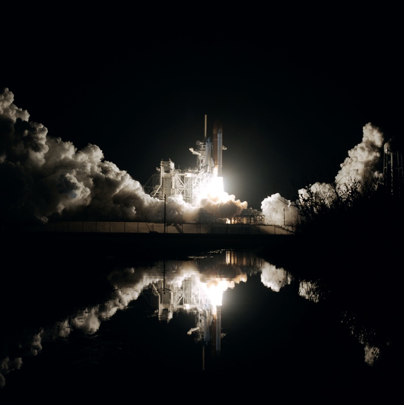
    http://www.nasa.gov/content/jan-12-1986-early-morning-space-shuttle-launch/#.VLZEWiwUX44

    Décollage de la navette le 12/01.1986. La photo est ,'est pas récente mais tellement belle !
    L'espace par l'image - Page 4 A13

    Jeannot
    Whisky Quebec


    L'espace par l'image - Page 4 Empty Re: L'espace par l'image

    Message par Jeannot Sam 7 Fév 2015 - 15:36

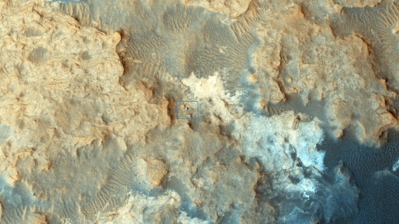
    Curiosity photographié par la camera HIRISE de Mars Orbiter

    L'espace par l'image - Page 4 A16

    Photographie prise le 13 décembre 2014. Le Rover est dans un cadre au centre de l'image avec son ombre dirigée vers le coin supérieur droit. Extraordinaire tout de même de pouvoir obtenir ce type de photographie. Non ?

    Curiosity Rover at 'Pahrump Hills'
    NASA's Curiosity Mars rover can be seen at the "Pahrump Hills" area of Gale Crater in this view from the High Resolution Imaging Science Experiment (HiRISE) camera on NASA's Mars Reconnaissance Orbiter.  Pahrump Hills is an outcrop at the base of Mount Sharp. The region contains sedimentary rocks that scientists believe formed in the presence of water.
    The location of the rover, with its shadow extending toward the upper right, is indicated with an inscribed rectangle. Figure A is an unannotated version of the image.  North is toward the top. The view covers an area about 360 yards (330 meters) across. 
    HiRISE made the observation on Dec. 13, 2014. At that time, Curiosity was near a feature called "Whale Rock."  A map showing the rover's path for the weeks leading up to that date is at http://mars.jpl.nasa.gov/msl/multimedia/images/?ImageID=6884 .  The inset map at http://mars.jpl.nasa.gov/msl/multimedia/images/?ImageID=6913 labels the location of Whale Rock and other features in the Pahrump Hills area.
    The bright features in the landscape are sedimentary rock and the dark areas are sand.  The HiRISE team plans to periodically image Curiosity, as well as NASA's other active Mars rover, Opportunity, as the vehicles continue to explore Mars.
    This image is an excerpt from HiRISE observation ESP_039280_1755. Other image products from this observation are available at http://hirise.lpl.arizona.edu/ESP_039280_1755 .
    The University of Arizona, Tucson, operates HiRISE, which was built by Ball Aerospace & Technologies Corp., Boulder, Colorado. NASA's Jet Propulsion Laboratory, a division of the California Institute of Technology in Pasadena, manages the Mars Reconnaissance Orbiter Project and Mars Science Laboratory Project for NASA's Science Mission Directorate, Washington. 
    Image Credit: NASA/JPL-Caltech/Univ. of Arizona
    http://www.nasa.gov/jpl/mro/pia19114/#.VNYf8izmlhq

    Jeannot
    Whisky Quebec


    L'espace par l'image - Page 4 Empty Re: L'espace par l'image

    Message par Jeannot Ven 13 Fév 2015 - 12:37

    Il y a quarante ans Apollo XIV  était sur la lune

    L'espace par l'image - Page 4 A17

    http://www.nasa.gov/content/forty-four-years-ago-today-apollo-14-touches-down-on-the-moon/#.VN3fjiwUX44
    eolien
    eolien
    Whisky Quebec


    L'espace par l'image - Page 4 Empty Re: L'espace par l'image

    Message par eolien Ven 13 Fév 2015 - 15:10

    Je ne vois pas son iPad ...


    _________________
    Eolien
    La dialectique est l'art d'atteindre la vérité au moyen de la discussion des opinions.
    Laurent Simon
    Laurent Simon
    Whisky Quebec


    L'espace par l'image - Page 4 Empty Re: L'espace par l'image

    Message par Laurent Simon Ven 6 Mar 2015 - 11:55

    Au sujet du survol récent de la comète par la sonde Rosetta,
    et quelques photos en très haute résolution prise à cette occasion

    Un vol au-dessus de Tchouri, ça vous botte ?

    http://www.journaldugeek.com/2015/03/05/rosetta-tales-un-vol-au-dessus-de-tchouri-ca-vous-botte/

    Voir aussi le fil spécifique :
    https://avia.superforum.fr/t1618-rosetta-philae#61382
    Zebulon84
    Zebulon84
    Whisky Quebec


    L'espace par l'image - Page 4 Empty Re: L'espace par l'image

    Message par Zebulon84 Sam 7 Mar 2015 - 3:10

    Vu Cérès, "planète naine" au cœur de la ceinture d’astéroïde entre Mars et Jupiter, vu par la sonde Dawn le 19 février dernier :

    L'espace par l'image - Page 4 601px-PIA18920-Ceres-DawnSpacecraft-Animation-20150219

    Les points lumineux intriguent toujours les astronomes qui n'ont pas d'explication définitive. Mais le reste de la planète étant très sombre, c'est probablement simplement un lieux avec une matière bien plus réfléchissante comme de la glace .
    Jeannot
    Jeannot
    Whisky Quebec


    L'espace par l'image - Page 4 Empty Re: L'espace par l'image

    Message par Jeannot Dim 8 Mar 2015 - 13:22

    Dans la continuité des messages précédents.


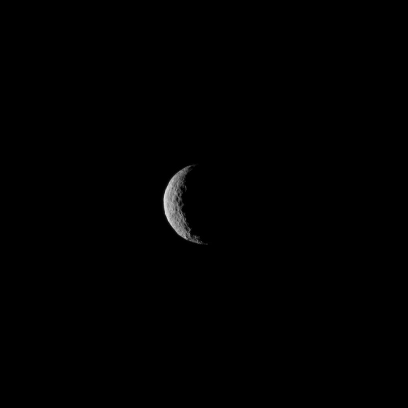
    La sonde Dawn se met en orbite autour de la planète naine Ceres

    L'espace par l'image - Page 4 A18

    Ceres Seen From NASA's Dawn Spacecraft
    NASA's Dawn spacecraft has become the first mission to achieve orbit around a dwarf planet. The spacecraft was approximately 38,000 miles (61,000) kilometers from Ceres when it was captured by the dwarf planet’s gravity at about 4:39 a.m. PST (7:39 a.m. EST) Friday, March 6.
    This image of Ceres was taken by the Dawn spacecraft on March 1, just a few days before the mission achieved orbit around the previously unexplored world. The image shows Ceres as a crescent, mostly in shadow because the spacecraft's trajectory put it on a side of Ceres that faces away from the sun until mid-April. When Dawn emerges from Ceres' dark side, it will deliver ever-sharper images as it spirals to lower orbits around the planet.
    The image was obtained at a distance of about 30,000 miles (about 48,000 kilometers) at a sun-Ceres-spacecraft angle, or phase angle, of 123 degrees. Image scale on Ceres is 1.9 miles (2.9 kilometers) per pixel. Ceres has an average diameter of about 590 miles (950 kilometers).
    Dawn's mission is managed by NASA's Jet Propulsion Laboratory, Pasadena, California, for NASA's Science Mission Directorate in Washington. Dawn is a project of the directorate's Discovery Program, managed by NASA's Marshall Space Flight Center in Huntsville, Alabama. The University of California, Los Angeles, is responsible for overall Dawn mission science. Orbital ATK Inc., in Dulles, Virginia, designed and built the spacecraft. The German Aerospace Center, the Max Planck Institute for Solar System Research, the Italian Space Agency and the Italian National Astrophysical Institute are international partners on the mission team. For a complete list of acknowledgments, http://dawn.jpl.nasa.gov/mission.

    http://www.nasa.gov/content/ceres-seen-from-nasas-dawn-spacecraft/#.VPw-VI7mlhp
    Laurent Simon
    Laurent Simon
    Whisky Quebec


    L'espace par l'image - Page 4 Empty Re: L'espace par l'image

    Message par Laurent Simon Ven 20 Mar 2015 - 19:22

    Comment Rosetta prend de sublimes clichés avec de vieux appareils photo

    http://tempsreel.nouvelobs.com/photo/20150227.OBS3529/comment-rosetta-prend-de-sublimes-cliches-avec-de-vieux-appareils-photo.html

    extraits :

    Des falaises escarpées et des jets de gaz colossaux sur fond de vide spatial : difficile de ne pas être sidéré par les paysages de la comète "Tchouri" qu'immortalise Rosetta, la sonde de l'Agence spatiale européenne (ESA).
    Depuis le placement du vaisseau en orbite autour de l'objet stellaire, puis l'atterrissage plein d'émotions du robot Philae, les images parviennent à la Terre à un rythme de métronome, nourrissant les études scientifiques et étanchant la soif d'images du public. 

    Quatre appareils photo répartis entre l'orbiteur Rosetta et l'atterrisseur Philae participent à découvrir les secrets de la comète 67P/Tchourioumov-Guérassimenko.

    L'appareil-star de la mission s'appelle Osiris. Pourquoi ce nom ? D'abord parce que l'ESA, s'étant inspirée de la pierre de Rosette pour nommer sa mission, se plaît depuis à puiser dans l'onomastique égyptienne. Ensuite parce qu'Osiris est l'acronyme – attention, jargon – de Optical, Spectroscopic, and Infrared Remote Imaging System, c'est-à-dire système d’imagerie optique, spectroscopique et infrarouge à distance.

    Intégré à la sonde, ce gros bébé de 30 kilos recèle en fait deux appareils photo : le premier, muni d'un grand angle, est destiné à cadrer la comète en son entier et le gaz qui en émane. Le second, pourvu d'une longue focale, réalise des plans rapprochés du noyau.

    Chacun dispose d'une batterie de filtres permettant d'atténuer la lumière du soleil ou d'analyser des aspects spécifiques de Tchouri. Bref, l'appareil Osiris est à l'image de son dieu tutélaire : il voit tout. Enfin, tout ce qui se trouve entre le proche infrarouge et l'ultraviolet.
    Laurent Simon
    Laurent Simon
    Whisky Quebec


    L'espace par l'image - Page 4 Empty Rosetta, les récentes photos prises lors du survol de la comète, très bas

    Message par Laurent Simon Lun 6 Avr 2015 - 13:23

    http://www.linformatique.org/lesa-publie-dincroyables-images-prises-par-rosetta/


    L’ESA publie d’incroyables images prises par Rosetta

    Exemple :
    L'espace par l'image - Page 4 Lesa-publie-dincroyables-images-prises-par-rosetta-620x330


    Dernière édition par Laurent Simon le Lun 6 Avr 2015 - 14:49, édité 1 fois
    Laurent Simon
    Laurent Simon
    Whisky Quebec


    L'espace par l'image - Page 4 Empty De superbes photos, prises par Sentinel1A, au cours de sa première année en orbite

    Message par Laurent Simon Lun 6 Avr 2015 - 14:44

    Des photos superbes, prise par le premier satellite (Sentinel 1A) de Copernicus, au cours de la première année en orbite :

    European Space Agency satellite captures stunning images of cityscapes, earthquakes and meandering glaciers

    http://news.nationalpost.com/news/world/european-space-agency-satellite-captures-stunning-images-of-cityscapes-earthquakes-and-meandering-glaciers

    Exemple, parmi les autres publiés à ce lien
    L'espace par l'image - Page 4 European-space-agency-sentinel-1The European Space Agency’s Sentinel mission has completed its inaugural year.


    Launched on April 3, 2014, Sentinel-1a — the vanguard of a fleet of satellites being launched by the ESA — carries a so-called synthetic aperture radar that provides continuous imagery of the earth’s surface no matter what the weather.


    The project, which is part of the ESA’s Copernicus program, was created for land and sea monitoring, mapping of natural disasters, and sea ice observation. Here, Bloomberg looks at some of the amazing imagery those first 12 months have produced, including incredible cityscapes, meandering glaciers, and the terrain following a magnitude 6.0 earthquake striking California’s Napa Valley in August, 2014.
    Laurent Simon
    Laurent Simon
    Whisky Quebec


    L'espace par l'image - Page 4 Empty Re: L'espace par l'image

    Message par Laurent Simon Lun 6 Avr 2015 - 14:53

    Laurent Simon a écrit:Comment Rosetta prend de sublimes clichés avec de vieux appareils photo

    http://tempsreel.nouvelobs.com/photo/20150227.OBS3529/comment-rosetta-prend-de-sublimes-cliches-avec-de-vieux-appareils-photo.html
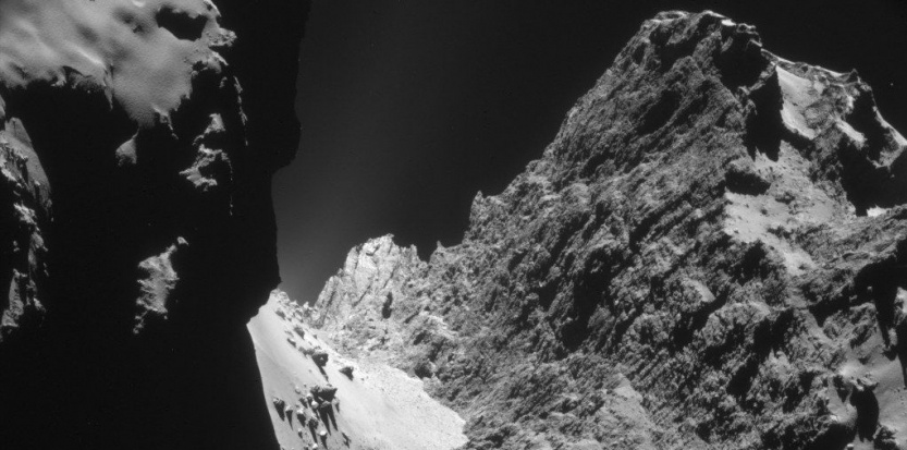
    J'aurais dû copier l'image : L'espace par l'image - Page 4 13746985
    Laurent Simon
    Laurent Simon
    Whisky Quebec


    L'espace par l'image - Page 4 Empty Une des permières photos prises par Sentinel1A, sur le tremblement de terre Napa Valley

    Message par Laurent Simon Lun 6 Avr 2015 - 15:21

    First Copernicus satellite now operational  (Sentinel1-A, voir le fil : https://avia.superforum.fr/t1504p20-programme-europeen-copernicus-ex-gmes-satellites-sentinel)

    http://phys.org/news/2014-10-copernicus-satellite.html

    L'espace par l'image - Page 4 3-firstcoperni
    Laurent Simon
    Laurent Simon
    Whisky Quebec


    L'espace par l'image - Page 4 Empty Rosetta : Des photos des jets de poussière par la comète.

    Message par Laurent Simon Jeu 23 Avr 2015 - 14:39

    Des photos des jets de poussière partant de la comète


    Rosetta probe sees comet sprout new dust jet for first time

    http://mashable.com/2015/04/21/rosetta-comet-dust/

    L'espace par l'image - Page 4 ESA_Rosetta_OSIRIS_WAC_20150312


    L'espace par l'image - Page 4 Comet_activity_31_January_25_March_2015
    Laurent Simon
    Laurent Simon
    Whisky Quebec


    L'espace par l'image - Page 4 Empty Comment 3 scans radar de Sentinel 1A peuvent être utilisés pour visualiser les cultures

    Message par Laurent Simon Mar 5 Mai 2015 - 18:46

    Une image qui combine 3 clichés radar (à différentes dates)

    depuis le satellite Sentinel 1A
    (programme européen Copernicus, de grande ampleur, le 2e juste après Galileo ; budget d'env. 4 milliards d'euros, pour la période 2014-2020, comportant une prévision de 3 786 M€  cf Wikipedia
    https://fr.wikipedia.org/wiki/Copernicus_%28programme%29#Chronologie )

    Central and Southern Italy

    http://www.scientificcomputing.com/news/2015/04/central-and-southern-italy

    L'espace par l'image - Page 4 Central_and_Southern_Italy_ml
     
    This image combines three radar scans from the Sentinel-1A satellite in October and December 2014.

    Focusing on the right side of the image, we can see how different colors represent changes between the acquisitions in the agricultural structures, due to plant growth or harvest.


    Dernière édition par Laurent Simon le Mar 5 Mai 2015 - 19:16, édité 1 fois
    Laurent Simon
    Laurent Simon
    Whisky Quebec


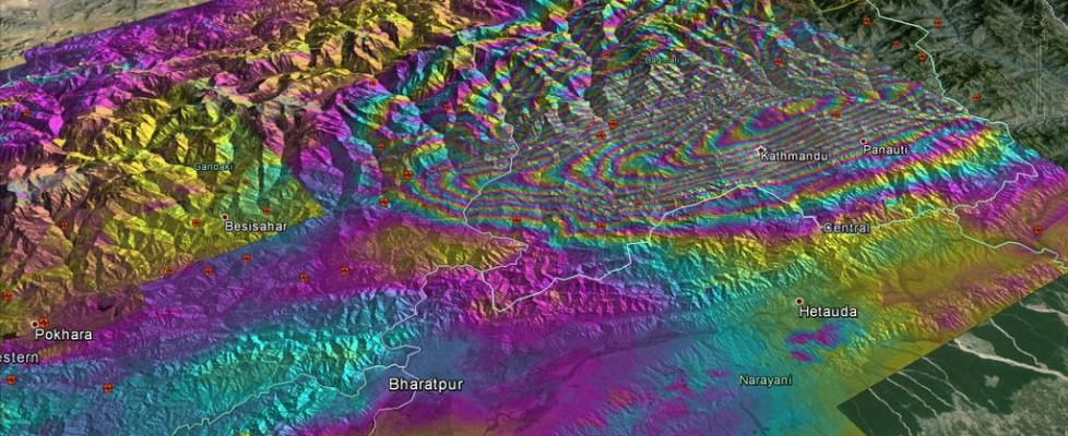
    L'espace par l'image - Page 4 Empty Sentinel 1A, observe le Népal (séisme)

    Message par Laurent Simon Mar 5 Mai 2015 - 18:57

    Une autre photo intéressante
    sur le Népal

    (site italien)

    L'espace par l'image - Page 4 160243848-63b552cc-dfc0-4cb9-b8b8-bcc3f43a3718

      http://www.repubblica.it/scienze/2015/05/01/news/il_terremoto_visto_dal_satellite-113307424/
    Laurent Simon
    Laurent Simon
    Whisky Quebec


    L'espace par l'image - Page 4 Empty Pluton, des images inédites. New Horizons.

    Message par Laurent Simon Ven 18 Sep 2015 - 18:02

    Pluton : des images spectaculaires et inédites de ses reliefs

    L'espace par l'image - Page 4 19a254f517_nh-apluto-wide-9-17-15-final_0

    Cette image de Pluton a été prise par la sonde New Horizons le 14 juillet 2015, à quelque 18.000 km de distance, 15 mn après le survol de la région Tombaugh et de la plaine Spoutnik.


    On aperçoit une partie de cette dernière, sur le limbe, à droite. Les montagnes qui la bordent, en bas et à sa gauche (est) sont Norgay Montes.


    Plus haut, sur l’horizon, on distingue Hillary Montes.


    Par-dessus, on compte, dans son atmosphère riche en azote, plus d’une douzaine de couches de brume jusqu’à 100 km d’altitude.


    L’image couvre une portion de 1.250 km. Téléchargez l’image en haute résolution ici (3,7 Mo). © Nasa, JHUAPL, SwRI


    ...
    L'espace par l'image - Page 4 RTEmagicC_nhpluto-mountains-plains-9-17-15

    Vue détaillée de la plaine Spoutnik (partie droite) et de ses glaciers coulants. À gauche et en bas, Norgay Montes.


    Certaines de ces montagnes culminent à 3.500 m.


    À l’horizon, les reliefs de Hillary Montes.


    Les brumes sont rétroéclairées par le Soleil couchant.


    L’image couvre une région qui s’étend sur 380 km. Téléchargez l’image en haute résolution ici (2,2 Mo). © Nasa, JHUAPL, SwRI
    Jeannot
    Jeannot
    Whisky Quebec


    L'espace par l'image - Page 4 Empty Re: L'espace par l'image

    Message par Jeannot Mer 24 Fév 2016 - 9:12

    Trois lunes de Saturne

    Trois lunes de Saturnen Téthys, Enceladus et Mimas prises par la sonde Cassini le 3 décembre 2015

    L'espace par l'image - Page 4 Pia18357-1041

    Three of Saturn's moons -- Tethys, Enceladus and Mimas -- are captured in this group photo from NASA's Cassini spacecraft.

    Tethys (660 miles or 1,062 kilometers across) appears above the rings, while Enceladus (313 miles or 504 kilometers across) sits just below center. Mimas (246 miles or 396 kilometers across) hangs below and to the left of Enceladus.

    This view looks toward the sunlit side of the rings from about 0.4 degrees above the ring plane. The image was taken in visible light with the Cassini spacecraft narrow-angle camera on Dec. 3, 2015.

    The view was acquired at a distance of approximately 837,000 miles (1.35 million kilometers) from Enceladus, with an image scale of 5 miles (8 kilometers) per pixel. Tethys was approximately 1.2 million miles (1.9 million kilometers) away with an image scale of 7 miles (11 kilometers) per pixel.  Mimas was approximately 1.1 million miles (1.7 million kilometers) away with an image scale of 6 miles (10 kilometers) per pixel.

    The Cassini mission is a cooperative project of NASA, ESA (the European Space Agency) and the Italian Space Agency. The Jet Propulsion Laboratory, a division of the California Institute of Technology in Pasadena, manages the mission for NASA's Science Mission Directorate, Washington. The Cassini orbiter and its two onboard cameras were designed, developed and assembled at JPL. The imaging operations center is based at the Space Science Institute in Boulder, Colorado.

    For more information about the Cassini-Huygens mission visit http://saturn.jpl.nasa.gov and http://www.nasa.gov/cassini . The Cassini imaging team homepage is at http://ciclops.org .

    http://www.nasa.gov/image-feature/jpl/pia18357/three-times-the-fun
    Jeannot
    Jeannot
    Whisky Quebec


    L'espace par l'image - Page 4 Empty Re: L'espace par l'image

    Message par Jeannot Ven 22 Avr 2016 - 10:53

    Curieuse photo d'Enceladus

    Prise par la sonde Cassini le 15 fevrier 2016, cette photo d'Enceladus, satellite de Saturne. Un pixel correspond à 580 mètres.

    L'espace par l'image - Page 4 Pia18366-1041

    A sinuous feature snakes northward from Enceladus' south pole like a giant tentacle. This feature, which stretches from the terminator near center, toward upper left, is actually tectonic in nature, created by stresses in Enceladus' icy shell.

    Geologists call features like these on Enceladus (313 miles or 504 kilometers across) "Y-shaped discontinuities." These are thought to arise when surface material attempts to push northward, compressing or displacing existing ice along the way. Such features are also believed to be relatively young based on their lack of impact craters -- a reminder of how surprisingly geologically active Enceladus is.

    This view looks towards the trailing hemisphere of Enceladus. North is up. The image was taken in visible green light with the Cassini spacecraft narrow-angle camera on Feb. 15, 2016.

    The view was obtained at a distance of approximately 60,000 miles (100,000 kilometers) from Enceladus. Image scale is 1,900 feet (580 meters) per pixel.

    http://www.nasa.gov/image-feature/jpl/pia18366/y-marks-the-spot
    Jeannot
    Jeannot
    Whisky Quebec


    L'espace par l'image - Page 4 Empty Re: L'espace par l'image

    Message par Jeannot Mer 27 Avr 2016 - 13:25

    Des échos de lumière utilisés pour étudier les disques protoplanétaires. 

    La Nasa a utilisé le télescope Spitzer et 4 télescopes terrestres pour mesure la distance entre une etoile et son disque protoplanétaire.

    Personnellement j'ai appris ce qu'était un disque protoplanétaire et pus la photo est belle. Non ?
    https://fr.wikipedia.org/wiki/Disque_protoplan%C3%A9taire

    L'espace par l'image - Page 4 Pia20645_main

    A new study published in the Astrophysical Journal uses data from NASA's Spitzer Space Telescope and four ground-based telescopes to determine the distance from a star to the inner rim of its surrounding protoplanetary disk. Researchers used a method called "photo-reverberation," also known as "light echoes." When the central star brightens, some of the light hits the surrounding disk, causing a delayed “echo.” Scientists measured the time it took for light coming directly from the star to reach Earth, then waited for its echo to arrive.
    The Spitzer study marks the first time the light echo method was used in the context of protoplanetary disks.
    This illustration shows a star surrounded by a protoplanetary disk. Material from the thick disk flows along the star’s magnetic field lines and is deposited onto the star’s surface. When material hits the star, it lights up brightly.

     http://www.nasa.gov/image-feature/light-echoes-used-to-study-protoplanetary-disks
    Jeannot
    Jeannot
    Whisky Quebec


    L'espace par l'image - Page 4 Empty Re: L'espace par l'image

    Message par Jeannot Jeu 5 Mai 2016 - 17:33

    Les couleurs de Nili Fossae sur Mars

    Quel jeu de couleurs pour une région de la planète rouge. On pourrait presque croire voir une photo de lnotre bonne vieille terre.

    L'espace par l'image - Page 4 Esp_044662_2010

    The Nili Fossae region, located on the northwest rim of Isidis impact basin, is one of the most colorful regions of Mars. The colors over many regions of Mars are homogenized by the dust and regolith, but here the bedrock is very well exposed, except where there are sand dunes. The rocks also have diverse compositions. This region is ancient and has had a complicated geologic history, leading to interesting structures like layered bedrock, as well as other compositions.
    This image of Nili Fossae was taken on Feb. 5, 2016, at 14:54 local Mars time by the High Resolution Imaging Science Experiment (HiRISE) camera on NASA's Mars Reconnaissance Orbiter. The University of Arizona, Tucson, operates HiRISE, which was built by Ball Aerospace & Technologies Corp., Boulder, Colo. NASA's Jet Propulsion Laboratory, a division of the California Institute of Technology in Pasadena, manages the Mars Reconnaissance Orbiter Project for NASA's Science Mission Directorate, Washington.
    Image Credit: NASA/JPL-Caltech/Univ. of Arizona
    Caption: Alfred McEwen

    Laurent Simon
    Laurent Simon
    Whisky Quebec


    L'espace par l'image - Page 4 Empty Re: L'espace par l'image

    Message par Laurent Simon Sam 1 Oct 2016 - 12:43

    J'avais oublié ce fil, image et vidéo,
    et je doublonne donc ici le dernier message, sur le fil Rosetta :

    La video sur l'article déjà cité :
    http://www.usinenouvelle.com/article/video-la-sonde-rosetta-a-termine-sa-mission-sur-la-comete-tchouri.N442317

    est vraiment excellente, mais je n'ai pas réussi à l'intégrer ici.
    Elle inclut des précisions non trouvées sur les articles que j'ai pu lire, y compris, par exemple, pourquoi il était plus difficile de faire "atterrir"
     la sonde Rosetta, et pourquoi il n'était pas sûr de garder le contact jusqu'à la fin.

    C'est en fait une vidéo Euronews, de 8mn,
    (qui est peut-être accessible et 'copiable' sur le site euronews)

    qui d'ailleurs inclut également env. 30 secondes à la fin pour évoquer Exomars, qui s'approche actuellement de Mars.

    et j'y ajoute cet article du Huffington Post :
    Les dernières photos prises par Rosetta avant de s'écraser sur Tchouri
    http://www.huffingtonpost.fr/2016/09/30/photos-rosetta-tchouri-ecraser_n_12260810.html

    qui inclut effectivement de superbes photos, dans la descente,
    que je n'ai pas réussi non plus à intégrer ici.
    Laurent Simon
    Laurent Simon
    Whisky Quebec


    L'espace par l'image - Page 4 Empty Re: L'espace par l'image

    Message par Laurent Simon Lun 17 Oct 2016 - 1:57

    Des vidéos, sur ExoMars 2016,
    sur le site de l'ESA, 
    ou  :http://livestream.com/ESA/marsarrival


    ExoMars separation confirmation

    At the end of this live webcast, at about 17:30 CEST on 16 October, the data link with the ExoMars/TGO orbiter had still not been fully re-established following separation. Subsequently, at around 18:40 CEST, ESA re-established a full data link with the spacecraft, and the mission control team could confirm that separation had taken place as planned, at 16:42 CEST. Both the Schiaparelli module and the TGO orbiter are in good shape and en route - seperately - to arrive at the Red Planet on 19 October.


    et :
    http://www.esa.int/Our_Activities/Space_Science/ExoMars/Live_updates_ExoMars_arrival_and_landing

    13 October 2016
    Updates from ESA’s space operations centre as the ExoMars Trace Gas Orbiter approaches and enters orbit around the Red Planet, and the Schiaparelli module lands on its surface
    Updates on this page will cover the following expected milestones:
    14 October: TGO final trajectory manoeuvre (08:45 GMT)
    16 October: Separation of Schiaparelli from TGO at 14:42 GMT / 16:42 CEST
    17 October: TGO orbit-raising manoeuvre at 02:42 GMT / 04:42 CEST
    19 October: TGO Mars orbit insertion and Schiaparelli entry, descent and landing on Mars (atmospheric entry expected 14:42 GMT / 16:42 CEST, landing 14:48 GMT / 16:48 CEST)
    20 October: Update on Schiaparelli status; descent images expected
    21+ October: Schiaparelli status reports until end of mission
    Note: Times shown above are actual event times at Mars; the one-way signal travel time between Earth and Mars is currently just under 10 minutes.
    The events of 16, 19 and 20 October will also be livestreamed here, all other events will be reported on this page and via Twitter from @esaoperations, @ESA_ExoMars, @ESA_TGO and @ESA_EDM, and via the hashtag #ExoMars.

    Mise à jour, au 16 octobre :
    16 October
    18:43 CEST: Full telemetry link with ExoMars/TGO has been restored via ESA's 35m deep-space ground station at Malargüe, Argentina. 
    18:30 CEST: The Schiaparelli module was released from the Trace Gas Orbiter (TGO) at 14:42 GMT (16:42 CEST) as planned.
    Today, three days before gravity will ensure the arrival of ExoMars 2016 at Mars, the Schiaparelli Entry, Descent & landing demonstrator Module separated from the TGO orbiter and is now en route on a ballistic trajectory to reach the Red Planet, enter its atmosphere and land softly in an area close to the equator known as Meridiani Planum.
    However, TGO unexpectedly did not return telemetry (on-board status information), and sent only its carrier signal, indicating it is operational. The anomaly that prevents TGO's telemetry from being sent is under investigation, and is expected to be resolved within the next few hours.
    An update will be posted in the next few hours.
    17:27 CEST: ExoMars Flight Director Michel Denis confirmed that separation of Schiaparelli has occurred and and signals from TGO have been reacquired. The signals do not contain the expected telemetry (information on the onboard status), and the teams are investigating the situation.
    17:02 CEST: Flight dynamics team at ESOC confirms separation of Schiaparelli from TGO on the basis of Doppler signal from the carrier. The Giant Metrewave Radio Telescope (GMRT) near Pune, India, has also recorded a very faint signal that indicates separation. Official confirmation expected soon when telemetry from TGO is received.
    16:42 CEST: According to the timeline, Schiaparelli should have separated from TGO. Confirmation is expected on Earth soon and will be announced by ExoMars Flight Director Michel Denis once the data is on ground.
    15:50 CEST: Both Schiaparelli and ExoMars/TGO are in good shape! The A-team shift of the mission control team are now on console in Main Control Room at ESOC. ExoMars/TGO has completed its slew into separation attitude/orientation. Communication now provided by ESA's 35m deep-space tracking station at New Norcia, Australia. Separation on track for 16:42 CEST.
    13:25 CEST: The separation timeline has started! Teams at ESOC are extremely busy monitoring the sequence of events scheduled for today's separation, expected at 16:42 CEST. Both the ExoMars/TGO orbiter and the Schiaparelli lander module are in great shape. The lander has been switched on and engineers monitoring telemetry - on-board status information - report that temperatures on Schiaparelli are nominal. ExoMars/TGO has already begun slewing - rotating in space - into the correct attitude for separation. Just prior to separation, at 16:31 CEST, mission controllers expect to lose the full data link with TGO, and then will follow progress by monitoring the basic unmodulated carrier signal only, as a sort of beacon. We may also see signals received via the GMRT radio telescope in Pune, India, although this is strictly an experiment and may not function as planned. One-way signal time today is 9 mins and 34 secs.
    10:10 CEST: Today, Schiaparelli, still attached to ExoMars/TGO, is switched on, and its systems checked out one final time. Experts from Thales Alenia Space (Italy) working at ESOC will verify the final set of time-tagged commands, which have been uploaded via TGO and stored on board Schiaparelli so that it can function more or less autonomously throughout its mission. TGO will eject Schiaparelli at 16:42 CEST, dispatching it on a three-day coast and a six-minute descent to the surface. Ground station coverage will be provided by NASA's giant 70m Deep Space Network (DSN) ground stations at Canberra, Australia, and Madrid, Spain, which will listen for the spacecraft's signals as the Schiaparelli module separates. It will be pushed away from TGO at just 30 cm/second, but this tiny push can be detected by the DSN stations.
    Laurent Simon
    Laurent Simon
    Whisky Quebec


    L'espace par l'image - Page 4 Empty Re: L'espace par l'image

    Message par Laurent Simon Dim 19 Mar 2017 - 13:49

    Des images obtenues par la sonde européenne-russe Exomars, en orbite autour de Mars, qui vise notamment à renifler l'atmosphère de Mars
     
    ExoMars science checkout completed and aerobraking begins
    March 16, 2017


    L'espace par l'image - Page 4 Exomarsscien
    Test images of Mars acquired by the ExoMars Trace Gas Orbiter’s high-resolution CaSSIS camera on 5 March 2017. The mosaic comprises 40 individual image frames captured using the near-infrared filter. The images were taken just as the orbiter was crossing the boundary between day and night, in the southern hemisphere of Mars. To the top left of the image is the centre of Mellish crater (26ºW, 73ºS). The image scale is 38 m/pixel. Credit: ESA/Roscosmos/CaSSIS , CC BY-SA 3.0 IGO
    The ExoMars Trace Gas Orbiter has completed another set of important science calibration tests before a year of aerobraking gets underway.
    Laurent Simon
    Laurent Simon
    Whisky Quebec


    L'espace par l'image - Page 4 Empty MASCOT, mission franco-allemande sur la sonde japonaise HayaBusa2 (astéroïde)

    Message par Laurent Simon Lun 8 Oct 2018 - 11:22

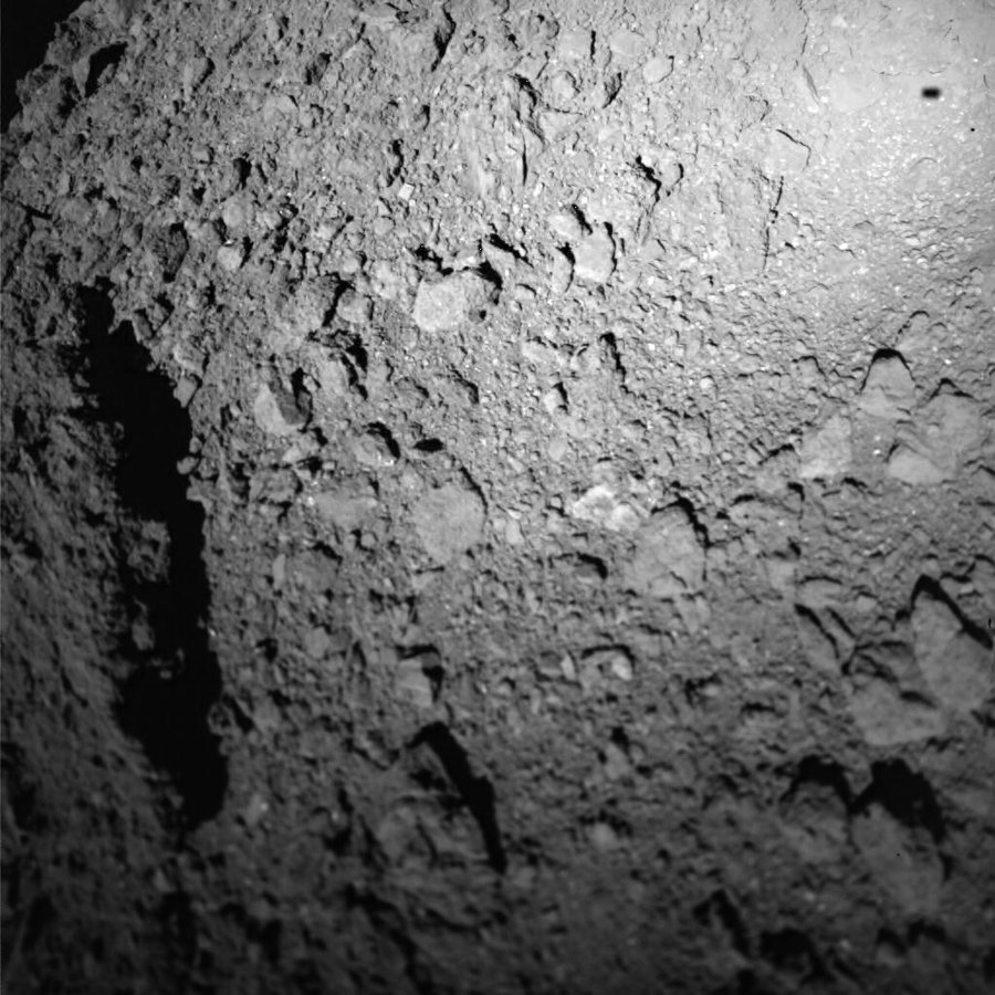
    La sonde japonaise HayaBusa2 ("faucon pèlerin" en japonais)
    qui inclut la mission MASCOT, petit frère de Philae

    voir https://avia.superforum.fr/t1618p100-rosetta-philae
    L'espace par l'image - Page 4 Bpc_ryugu-mascot

    Photographie du sol de l'astéroïde Ryugu réalisée le 3 octobre 2018 pendant l'atterrissage de MASCOT à plus de 300 millions de km de la Terre. Crédits : CNES/DLR/JAXA.

    avec deux vidéos

    https://youtu.be/clCAyP466lo?list=PLHWdbfW26EsZ8EzD3-JIlpvmroGzOE9ul

    https://youtu.be/9y8rIVcvlc0?list=PLHWdbfW26EsZ8EzD3-JIlpvmroGzOE9ul


    et une autre

    Laurent Simon
    Laurent Simon
    Whisky Quebec


    L'espace par l'image - Page 4 Empty Re: L'espace par l'image

    Message par Laurent Simon Mer 24 Oct 2018 - 10:53

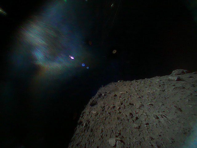
    Plusieurs photos depuis l'astéroïde Ryugu

    https://www.generation-nt.com/hayabusa-2-rovers-asteroide-ryugu-actualite-1957603.html

    L'espace par l'image - Page 4 DnszMxtUUAAS_cD?format=jpg&name=small

    L'espace par l'image - Page 4 Dns1vIhU8AEJeXX?format=jpg&name=small
    Laurent Simon
    Laurent Simon
    Whisky Quebec


    L'espace par l'image - Page 4 Empty Re: L'espace par l'image

    Message par Laurent Simon Ven 26 Oct 2018 - 10:01

    https://www.usinenouvelle.com/photos/innovation/en-images-en-quete-de-nouveaux-mondes-depuis-les-nouveaux-telescopes-de-l-eso-au-chili.664434/en-utilisant-la-metho.1

    L'espace par l'image - Page 4 Extra

    Contenu sponsorisé


    L'espace par l'image - Page 4 Empty Re: L'espace par l'image

    Message par Contenu sponsorisé


      La date/heure actuelle est Lun 18 Nov 2024 - 0:45