ACTUALITE Aéronautique

Vous souhaitez réagir à ce message ? Créez un compte en quelques clics ou connectez-vous pour continuer.
ACTUALITE Aéronautique

ACTUALITE Aéronautique : Suivi et commentaire de l\'actualité aéronautique

Le Deal du moment : -40%
-40% sur le Pack Gaming Mario PDP Manette filaire + ...
Voir le deal
29.99 €

4 participants

    Programme européen Copernicus (ex GMES). Satellites Sentinel


    Laurent Simon
    Whisky Quebec


    Programme européen Copernicus (ex GMES). Satellites Sentinel - Page 3 Empty Une nouvelle image, spectaculaire, de l'espace, grâce à Sentinel 2A (Copernicus)

    Message par Laurent Simon Ven 18 Sep 2015 - 16:21

    Une nouvelle image, spectaculaire, de l'espace, grâce à Sentinel 2A (Copernicus) : un lac salé en Australie.

    http://phys.org/news/2015-09-image-australian-captured-copernicus-sentinel.html

    Programme européen Copernicus (ex GMES). Satellites Sentinel - Page 3 Imageaustral

    Laurent Simon
    Whisky Quebec


    Programme européen Copernicus (ex GMES). Satellites Sentinel - Page 3 Empty Re: Programme européen Copernicus (ex GMES). Satellites Sentinel

    Message par Laurent Simon Ven 18 Sep 2015 - 16:27

    Laurent Simon a écrit:Le satellite Sentinel 1 A montre très vite son utilité
    par comparaison de deux prises de vue mi août 2015

    Greenland Glacier Loses Huge Chunk of Ice

    http://www.zmescience.com/science/oceanography/greenland-glacier-jakobshavn-24082015/

    Scientists have reported the break of a huge part of Jakobshavn Glacier, one of the largest ones in Greenland. A chunk of it roughly the size of Manhattan broke some time between August 13 and August 19.
    Pour compléter ce message,
    avec des photos :

    https://www.satnews.com/story.php?number=1439176891

    Programme européen Copernicus (ex GMES). Satellites Sentinel - Page 3 55ddf7c6e61fc

    Programme européen Copernicus (ex GMES). Satellites Sentinel - Page 3 55ddf82318436

    La perte de l'énorme iceberg :

    http://theweatherspace.com/2015/08/28/123406-greenland-glacier-calves-massive-iceberg/

    Programme européen Copernicus (ex GMES). Satellites Sentinel - Page 3 Greenland2

    Laurent Simon
    Whisky Quebec


    Programme européen Copernicus (ex GMES). Satellites Sentinel - Page 3 Empty Sentinel 2A : superbe photo de dunes de sable en Lybie.

    Message par Laurent Simon Ven 18 Sep 2015 - 16:36

    Libya's Sand Dunes

    Programme européen Copernicus (ex GMES). Satellites Sentinel - Page 3 Libya_Sand_Dunes_sm

    http://www.scientificcomputing.com/news/2015/09/libyas-sand-dunes
    Laurent Simon
    Laurent Simon
    Whisky Quebec


    Programme européen Copernicus (ex GMES). Satellites Sentinel - Page 3 Empty Re: Programme européen Copernicus (ex GMES). Satellites Sentinel

    Message par Laurent Simon Ven 18 Sep 2015 - 16:42

    http://www.sci-news.com/space/science-sentinel-2a-algal-storm-03217.html

    Une tempête d'algues en Mer Baltique :

    Programme européen Copernicus (ex GMES). Satellites Sentinel - Page 3 Image_3217_1e-Algal-Storm
    Poncho (Admin)
    Poncho (Admin)
    Whisky Charlie


    Programme européen Copernicus (ex GMES). Satellites Sentinel - Page 3 Empty Re: Programme européen Copernicus (ex GMES). Satellites Sentinel

    Message par Poncho (Admin) Ven 18 Sep 2015 - 22:25

    Merci
    Sur la dernière on devine la résolution de ces photos. Le bateau est un petit bateau de plaisance ?


    _________________
    @avia.poncho
    Laurent Simon
    Laurent Simon
    Whisky Quebec


    Programme européen Copernicus (ex GMES). Satellites Sentinel - Page 3 Empty Re: Programme européen Copernicus (ex GMES). Satellites Sentinel

    Message par Laurent Simon Ven 13 Nov 2015 - 19:51

    Comment l'ESA va gérer le défi lié au torrent de données créé par le(s) satellite(s) Sentinel 2
    (programme UE-ESA Copernicus, ex GMES)

      Europe's eyes in space: How ESA's Sentinel-2 satellite scans pose petabyte challenge

    http://www.zdnet.com/article/europes-eyes-in-space-how-esas-sentinel-2-satellite-scans-pose-petabyte-challenge/

    Début de l'article
    "By next year the Sentinel-2 mission will be capable of obtaining complete coverage of the Earth's land surface every five days. That potentially represents a huge amount of data for the European Space Agency to handle.

    When the European Space Agency's Sentinel-2B satellite joins its 2A twin in orbit next year, the project's volume of data in the form of images of the Earth's surface will soar to up to two petabytes annually.

    To cope with that data growth, ESA has just expanded the 2013 contract it awarded Spanish company Indra to take it up to 2020 and to include data management for the twin satellites.
    Robust long-term global records of essential climate variables, such as greenhouse gas concentrations, sea-ice extent and thickness, and sea-surface temperature and salinity, are crucial to understanding and mitigating the consequences of climate change.

    Europe's eyes in space focused on Earth are provided by the Copernicus program, headed by the European Commission in partnership with ESA, which coordinates the delivery of data from upwards of 30 satellites. Among them are the Sentinels, which provide a unique set of observations that need to be processed and archived.

    ESA's initial 2013 contract with Indra used the company's facilities at San Fernando de Henares, 15km from Madrid, as one of the main data-processing and archiving centers, or PACs, for the Sentinel-2A satellite mission's ground segment."
    Laurent Simon
    Laurent Simon
    Whisky Quebec


    Programme européen Copernicus (ex GMES). Satellites Sentinel - Page 3 Empty Re: Programme européen Copernicus (ex GMES). Satellites Sentinel

    Message par Laurent Simon Mer 18 Nov 2015 - 22:33

    Article d'il y a près d'un mois :

    Europe Grants U.S. Special Access to Copernicus Earth-observation Data

      http://spacenews.com/europe-grants-u-s-special-access-to-copernicus-earth-observation-data/

    Accord entre les E.U. et l'UE selon lequel les agences US auront libre accès aux données obtenues par les satellites Sentinel du programme européen Copernicus.

    Comme retour au libre accès à Landsat, que les autorités US nous avait accordé.

    The European Commission and the U.S. government have reached an agreement under which U.S. agencies will have free access to Europe’s Copernicus environment-monitoring satellite constellation -
    Laurent Simon
    Laurent Simon
    Whisky Quebec


    Programme européen Copernicus (ex GMES). Satellites Sentinel - Page 3 Empty le satellite Sentinel 3A se prépare au lancement, en décembre 2015

    Message par Laurent Simon Mer 18 Nov 2015 - 22:40

    Copernicus : le satellite Sentinel 3A se prépare au lancement

    http://www.futura-sciences.com/magazines/espace/infos/actu/d/copernicus-copernicus-satellite-sentinel-3a-prepare-lancement-60178/

    Extraits :
    "En décembre, Sentinel 3A sera le troisième satellite du programme européen Copernicus à être mis en orbite.

    Il a pour objectif l’observation en permanence des océans et des surfaces terrestres par optique multispectrale, infrarouge et altimétrie.

    Sa construction a dû tenir compte d’un certain nombre de contraintes techniques et opérationnelles en raison des objectifs scientifiques de la mission."

    "Après les lancements de Sentinel 1A (avril 2014) et Sentinel 2A (juin 2015), se prépare celui de Sentinel 3A. Le satellite sera lancé le 10 décembre par un lanceur russe, Rockot, depuis le cosmodrome de Plessetsk.

    Initialement, il devait être lancé par Vega, mais les premiers lancements de ce lanceur étaient déjà réservés par d'autres missions. Sentinel 3B sera quant à lui bien lancé par Vega.

    Sentinel 3 fait partie d'une mission d’observation de la surface des océans et des terres émergées au moyen d'instruments optiques à moyenne résolution fonctionnant dans le visible (couleur), le proche infrarouge et l'infrarouge lointain (température), mais aussi d’instruments radars fonctionnant par tout temps et permettant notamment de déterminer les hauteurs des océans et des grands lacs.

    Le satellite embarque quatre instruments principaux et un ensemble d'outils de navigation :

    • les instruments OLCI (Ocean and Land Color Instrument) et SLSTR (Sea and Land Surface Temperature Radiometer) pour la partie optique de la mission ;
    • deux instruments micro-ondes qui forment la charge utile topographique : l'altimètre radar SRAL (Sar Radar Altimeter) complété d’un radiomètre (MWR).

    "
    Laurent Simon
    Laurent Simon
    Whisky Quebec


    Programme européen Copernicus (ex GMES). Satellites Sentinel - Page 3 Empty Re: Programme européen Copernicus (ex GMES). Satellites Sentinel

    Message par Laurent Simon Lun 7 Déc 2015 - 15:29

    Une image créée à partir des données Copernicus Sentinel 1A

    Image: Dutch mosaic from Copernicus Sentinel data

    Programme européen Copernicus (ex GMES). Satellites Sentinel - Page 3 Imagedutchmo
    Laurent Simon
    Laurent Simon
    Whisky Quebec


    Programme européen Copernicus (ex GMES). Satellites Sentinel - Page 3 Empty Re: Programme européen Copernicus (ex GMES). Satellites Sentinel

    Message par Laurent Simon Sam 19 Déc 2015 - 14:11

    T.A.S. va construire les satellites Sentinel 1-C et D, du programme Copernicus.

    http://www.telesatellite.com/actu/46409-thales-alenia-space-va-construire-les-satellites-sentinel-1c-et-de-copernicus.html
    Thales Alenia Space va construire les sac plastiques Sentinel-1C et D de Copernicus
    Thales Alenia Space va construire les sac plastiques Sentinel-1C et D de Copernicus
    Thales Alenia Space va construire les sac plastiques Sentinel-1C et D de Copernicusvvv
    Laurent Simon
    Laurent Simon
    Whisky Quebec


    Programme européen Copernicus (ex GMES). Satellites Sentinel - Page 3 Empty Re: Programme européen Copernicus (ex GMES). Satellites Sentinel

    Message par Laurent Simon Mer 15 Juin 2016 - 14:17

    Copernicus Atmosphere Monitoring Service (CAMS) Announces a Major Improvement on Atmosphere Data Accessibility

    http://www.prnewswire.com/news-releases/copernicus-atmosphere-monitoring-service-cams-announces-a-major-improvement-on-atmosphere-data-accessibility-582887411.html


    "At the first CAMS summit in Athens on 14-16 June, ECMWF, in charge of CAMS on behalf of the European Commission, will launch a radically new interactive and ready to use version of its online platform of atmosphere data. Policy makers, scientific and business communities or citizens will benefit from an enhanced free-to-access array of customisable and "live" maps and charts in just a few clicks.

    Some of today's most important environmental concerns relate to the composition of the atmosphere. The increasing concentration of the greenhouse gases and the cooling effect of aerosol are prominent drivers of a changing climate, but the extent of their impact is often still uncertain.
    Air quality is also one of the major concerns throughout the world, affecting human health and life expectancy, the health of ecosystems and the fabric of the built environment.

    The European Union's Copernicus Earth Observation programme uses and contributes to a worldwide network of thousands of sensors on land, in our oceans, and in the air, as well as a network of over 50 satellites providing millions of environmental readings every day.

    To address these environmental concerns there is a need for data and processed information that is easily accessible.
    That means, not only free of charge, but ready to use and designed to match users' needs.

    Instant online design "à la carte" 
    To see the video presentation of the new CAMS online platform: https://youtu.be/r-nhoTxkR8U 

    The new CAMS interface provides dynamic visualisations without the need to download data into specialist tools or software, giving users access to maps, charts, animations and local time series based on information about atmospheric chemistry as generated by the Copernicus programme.

    The Catalogue component provides the basis for users to easily find the many products, be it data, maps or documents. It includes an intuitive search system, improved filtering and clear display of the resulting information.

    The new catalogue marks an important step in broadening access to the wealth of CAMS data as part of Copernicus's mission, supporting society to understand and adapt to our changing environment through world-leading science and technology

    Examples of maps that will be displayed:

    1. Global surface forecasts e.g. forecasts for levels and movement of carbon monoxide, sulphur dioxide, ozone, nitrogen dioxide and formaldehyde in the surface layer (the air that we breathe)
      http://atmosphere.copernicus.eu/maps/global-surface-forecasts
    2. Global total column forecasts e.g. Forecasts for total levels and movement of carbon monoxide, sulphur dioxide, ozone, nitrogen dioxide and formaldehyde in all levels of the earth's atmosphere
      http://atmosphere.copernicus.eu/maps/global-total-column-forecasts
    3. Aerosol forecasts e.g. airborne pollutants such as those caused by dust storms
      http://atmosphere.copernicus.eu/maps/aerosol-forecasts
    4. Fire emissions e.g. emissions from biomass burning and wildfires
      http://atmosphere.copernicus.eu/maps/fire-activity


    New functionalities will include:

    • Global or regional views
    • Panning
    • Zoom
    • Fullscreen view
    • Social media sharing
    • Animated forecasts
    • On-the-fly data layer selection
    • Point-and-click chart generation from the maps

    ...


    Press Pictures 
    All pictures can be used with reference to ECMWF Copernicus and are downloadable here: http://atmosphere.copernicus.eu/news-and-media/press-room/press-resources/press-photos


    •      (Photo: http://photos.prnewswire.com/prnh/20160613/378873 )
      Graphic 1: Live maps embedded in the CAMS website, readily accessible for users. (ECMWF Copernicus).


    •      (Photo: http://photos.prnewswire.com/prnh/20160613/378874 )


    Graphic 2: Audience can use data without specialists' tools. They can use the interface to pan, zoom and make point & click investigations. In addition, they can play time animation series to understand data evolution (ECMWF Copernicus).


    •      (Photo: http://photos.prnewswire.com/prnh/20160613/378875 )

    Graphic 3: The new user interface of the CAMS Catalogue compared to its precursor with an improved user experience: Easier to understand the data content at-a-glance and increased functionalities (ECMWF Copernicus).
    Laurent Simon
    Laurent Simon
    Whisky Quebec


    Programme européen Copernicus (ex GMES). Satellites Sentinel - Page 3 Empty Face aux inondations, les capacités "anti crises" de Copernicus ont été activées en juin

    Message par Laurent Simon Ven 17 Juin 2016 - 18:08

    Copernicus ou quand l’imagerie satellite permet d’aider à la gestion des catastrophes naturelles

    http://fr.euronews.com/2016/06/03/copernicus-ou-quand-l-imagerie-satellite-permet-d-aider-a-la-gestion-des/

    Pour aider la France et l’Allemagne à faire face aux inondations, le Service de gestion des situations d’urgence Copernicus a été activé. Géré conjointement par l’Agence Spatiale européenne et la Commission européenne, il utilise l’imagerie par satellite pour aider les secours à agir vite là où il le faut.
    Par rapport aux images aériennes ou celles prises par les drones, les images satellites présentent l’avantage de couvrir des zones beaucoup plus importantes, explique Stéphanie Battiston.

    En France, nous pouvons couvrir le bassin de la rivière Le Loing dans son ensemble. Et lorsqu’il faut surveiller la situation sur plusieurs jours, nous pouvons voir l’ensemble du bassin d’un seul coup chaque jour.”

    Stéphanie Battiston est l’une des responsables du Sertit, la structure qui traite les données du système Copernicus pour les rendre lisibles par les services d’intervention.
    “Nous fournissons des cartes chaque jour en fonction des demandes des utilisateurs, ajoute-t-elle. Cela leur permet non seulement de dimensionner les équipes de secours nécessaires sur le terrain mais aussi de savoir où les envoyer précisément en priorité.”
    Ce système est utilisé pour les catastrophes naturelles mais aussi celles d’origine humaine comme les marées noires, ainsi que dans la gestion des crises humanitaires.
    Laurent Simon
    Laurent Simon
    Whisky Quebec


    Programme européen Copernicus (ex GMES). Satellites Sentinel - Page 3 Empty Re: Programme européen Copernicus (ex GMES). Satellites Sentinel

    Message par Laurent Simon Mer 20 Juil 2016 - 18:48

    un article qui date d'un an, mais qui reste intéressant.

    http://optics.org/news/6/6/48

    le début de l'article :
    Sentinel satellite returns 'game-changing' multispectral imagery
    30 Jun 2015
    Sofradir and e2v sensors helping to take remote land monitoring to unprecedented levels, says the European Space Agency.
    Programme européen Copernicus (ex GMES). Satellites Sentinel - Page 3 Sentinel2Apovalley
    Po Valley: the SWIR view
    High-resolution multispectral images captured by the optical sensors on board the Sentinel-2A satellite launched last week are already being beamed back to Earth – yielding views with unprecedented spectral detail and resolution.
    The European Space Agency (ESA) payload, one of several that will eventually make up the “Copernicus” constellation, covers 13 discrete bands across the visible and near-infrared spectral regions and combines that with a 290 km swath width and a ground resolution of 10 meters per pixel.
    Sentinel-2A’s first image acquisition captured a view extending from Sweden to Algeria, through a large chunk of central Europe. It included a close-up the Po Valley in Italy, processed through the satellite’s high-resolution infrared channel. The French company Sofradir provided 12 infrared sensors for Sentinel-2A.
    Laurent Simon
    Laurent Simon
    Whisky Quebec


    Programme européen Copernicus (ex GMES). Satellites Sentinel - Page 3 Empty Re: Programme européen Copernicus (ex GMES). Satellites Sentinel

    Message par Laurent Simon Sam 30 Juil 2016 - 13:38

    Les nouveaux moyens, européens, avec Cryosat et Sentinel 3, permettent de faire des mesures beaucoup plus précises du niveau de la mer

    (ce qui est très important, à la fois pour mieux comprendre le fonctionnement de la planète, le dérèglement climatique et pour mieux appréhender les catastrophes naturelles et en atténuer les conséquences pour l'humanité),

    en particulier près des côtes, comme en Norvège.

    CryoSat sets new standard for measuring sea levels

    http://phys.org/news/2016-07-cryosat-standard-sea.html
      

    Programme européen Copernicus (ex GMES). Satellites Sentinel - Page 3 Cryosatsetsn
    The rugged coastal landscape of Stavanger in southwest Norway, with its distinctive rocks and hills was captured by the Sentinel-2A satellite on 15 March 2016. Credit: Contains modified Copernicus Sentinel data (2016), processed by ESA
    Laurent Simon
    Laurent Simon
    Whisky Quebec


    Programme européen Copernicus (ex GMES). Satellites Sentinel - Page 3 Empty Re: Programme européen Copernicus (ex GMES). Satellites Sentinel

    Message par Laurent Simon Sam 30 Juil 2016 - 14:39

    En prolongement du post sur 'La politique spatiale européenne (UE, ESA), la dimension européenne de l'espace. '

    d'autres extraits du même article :
    Europe's workhorse Sentinel ready for action

    http://phys.org/news/2016-07-europe-workhorse-sentinel-ready-action.html

    "Hilary Wilson, Eumetsat's Sentinel-3 project manager, added, "After this intense five-month period we are looking forward to taking over the routine operations of the satellite from ESA and moving into what will hopefully be more than a decade of smooth operations bringing these important data to users worldwide.
    "Working together with ESA, we are proud to have achieved this important milestone."

    Programme européen Copernicus (ex GMES). Satellites Sentinel - Page 3 1-europesworkh
    Baltic swirls. Credit: Contains modified Copernicus Sentinel data (2016)/HZG

    The data have already been put through a reality check.
    As part of the commissioning phase, ESA and Eumetsat engaged with users, who have provided feedback on these sample data products.


    Susanne Mecklenburg, ESA's Sentinel-3 mission manager, said,
    "It is very exciting to see the first data already being looked at by the operational and scientific community – the people who asked for the continuity of such measurements and defined their requirements in the first place.


    "After only five months of commissioning, we have already released samples for most types of data products. The coming months will see a gradual ramp-up of our processing and data dissemination activities to make sure that the user community is served in the best possible way.

    "The intention is to release first operationally qualified data products to all users in September."

    The full mission comprises two satellites flying in a constellation to meet the demanding coverage and revisit needs of the Copernicus Services.

    So while Sentinel-3A is well on the road to start delivering data that is expected to make unique contribution to the paradigm shift in monitoring our planet,
    ESA remains busy preparing its identical twin for launch in 2017
    .
    "
    Laurent Simon
    Laurent Simon
    Whisky Quebec


    Programme européen Copernicus (ex GMES). Satellites Sentinel - Page 3 Empty Re: Programme européen Copernicus (ex GMES). Satellites Sentinel

    Message par Laurent Simon Mer 31 Aoû 2016 - 17:59

    Sentinel-1 provides new insight into Italy's earthquake


    http://www.spacedaily.com/reports/Sentinel_1_provides_new_insight_into_Italys_earthquake_999.html


    Programme européen Copernicus (ex GMES). Satellites Sentinel - Page 3 Sentinel-1-source-fault-italy-quake-aug-2016-lg
    Scientists from Italy's National Institute for Geophysics and Volcanism combined Sentinel-1 radar acquisitions over central Italy from before and after the 24 August earthquake to calculate the location, geometry and amount of slip on the source fault. The slip is distributed mainly in two patches of about 1 m. The aftershock seismicity (black dots) is clearly surrounding these patches, releasing the remaining stress along the fault. The red star is the main shock. Green stars indicate the highest aftershocks of the sequence (M > 4.3). Image courtesy Copernicus Sentinel data (2016)/ESA/INGV. For a larger version of this image please go here.
    Laurent Simon
    Laurent Simon
    Whisky Quebec


    Programme européen Copernicus (ex GMES). Satellites Sentinel - Page 3 Empty Re: Programme européen Copernicus (ex GMES). Satellites Sentinel

    Message par Laurent Simon Mer 31 Aoû 2016 - 18:01

    Sentinel 1: un satellite aiuta a studiare il terremoto

    http://www.focus.it/scienza/scienze/come-sentinel-1-aiuta-a-vedere-e-studiare-il-terremoto


    Il satellite dell'Esa ha documentato dallo spazio lo sprofondamento e lo spostamento del terreno lungo la faglia, nelle zone del terremoto del Centro Italia.
    Programme européen Copernicus (ex GMES). Satellites Sentinel - Page 3 Ground_displacement_from_italy_s_earthquake_node_full_image_2.630x360
    Mappa rilasciata il 29 agosto: i ricercatori dell'Istituto per il rilevamento Elettromagnetico dell'Ambiente hanno combinati dati radar di Sentinel-1 rilevati prima e dopo l'evento del 24 agosto, in particolare il 15, il 21 e il 27 agosto. Lo studio evidenzia uno sprofondamento (subsidenza) di circa 20 cm nell'area di Accumoli (Rieti) e scostamenti laterali fino a 16 cm. Le linee blu seguono il tracciato della faglia
    Poncho (Admin)
    Poncho (Admin)
    Whisky Charlie


    Programme européen Copernicus (ex GMES). Satellites Sentinel - Page 3 Empty Re: Programme européen Copernicus (ex GMES). Satellites Sentinel

    Message par Poncho (Admin) Jeu 1 Sep 2016 - 11:45

    Tiens Sentinel a pris un petit choc
    Rien de grave

    http://www.air-cosmos.com/un-trou-de-40-cm-dans-un-panneau-solaire-de-sentinel-1a-81833?utm_source=Sociallymap&utm_medium=Sociallymap&utm_campaign=Sociallymap


    _________________
    @avia.poncho
    Laurent Simon
    Laurent Simon
    Whisky Quebec


    Programme européen Copernicus (ex GMES). Satellites Sentinel - Page 3 Empty Re: Programme européen Copernicus (ex GMES). Satellites Sentinel

    Message par Laurent Simon Ven 18 Nov 2016 - 20:18

    A propos des satellites Sentinel (programme Copernicus), dont le prochain à être mis sur orbite est le jjumeau de Sentinel 1A (lancé le 23 juin 2015), sera lancé dans quelques mois, par Vega :

    http://www.spaceflightinsider.com/organizations/esa/esas-sentinel-2b-spacecraft-steps-spotlight/

    image: http://www.spaceflightinsider.com/wp-content/uploads/2016/11/8495-esa_soyuz_sentinel_2-jacques_van_oene.jpg
    Programme européen Copernicus (ex GMES). Satellites Sentinel - Page 3 8495-esa_soyuz_sentinel_2-jacques_van_oene
    ESA held a tour of the new Sentinel 2B spacecraft on Tuesday, Nov. 15. The spacecraft is being prepared for a March 2017 launch atop a Vega booster from Kourou, French Guiana. Photo Credit: Jacques van Oene / SpaceFlight Insider


    "The European Space Agency (ESA) provided a glimpse of the Sentinel-2B satellite that is set to launch atop a Vega rocket from Kourou, French Guiana, during a media event held on Tuesday, Nov. 15. The spacecraft’s review helped set the stage for its flight, which is currently set for this spring


    ... When it is deployed, Sentinel-2B will fly 180° opposite Sentinel-2A, with both spacecraft occupying Sun-synchronous orbits at an altitude of approximately 488 miles (786 km) and covering Earth’s land surfaces, large islands, inland and coastal waters between 84°N and 56°S every five days.

    Both satellites have an operational design lifetime of 7.5 years with consumable propellants aboard for up to 12 years. They will provide high-resolution Earth observation services for ESA and provide data continuity for information that had been previously provided by SPOT-5 and Landsat 7.

    Sentinel-2B is 11.2 feet (3.4 m) long, 5.9 feet (1.8 m) wide, and 7.7 feet (2.35 m) tall. The spacecraft has a gross mass of 2,513 pounds (1,140 kg), which includes 273 pounds (123 kg) of propellant. It will launch aboard a European Vega launch vehicle in March 2017.

    Copernicus, I think it’s safe to say, is the world’s best program for environmental monitoring, there’s nothing comparable in any other part of the world,” Aschbacher
    (ESA’s Director of Earth Observation Programmes) said.
    Laurent Simon
    Laurent Simon
    Whisky Quebec


    Programme européen Copernicus (ex GMES). Satellites Sentinel - Page 3 Empty Re: Programme européen Copernicus (ex GMES). Satellites Sentinel

    Message par Laurent Simon Mer 15 Mar 2017 - 21:51

    avec un peu de retard,
    le lancement réussi, par Véga (9e succès) du satellite jumeau de Sentinel 2A, déjà lancé (il y a 9 mois)
    http://www.air-cosmos.com/sentinel-2b-complete-la-vision-couleur-de-copernicus-90937

    Programme européen Copernicus (ex GMES). Satellites Sentinel - Page 3 58be9288b4a88
    "Sentinel 2B constitue le cinquième satellite du programme européen de surveillance environnementale Copernicus, mis en place par l'ESA pour la Commission européenne de l’Europe depuis 2013. C'est également le quatrième exemplaire de la famille lancé par Arianespace depuis juin 2014, après les Sentinel 1A, 2A et 1B."

    il ... embarque le même instrument optique multispectral MSI (MultiSpectral Instrument), installé sur la plateforme AstroBus L. Ses prises de vue à haute résolution (10, 20 ou 60 m) et à large fauchée (290 km de large) couvrent 13 bandes spectrales, dans la gamme du visible et de l’infrarouge proche du spectre électromagnétique. Les données seront transférées par laser vers les satellites géostationnaires EDRS, via l’autoroute de l’information SpaceDataHighway développée par Airbus, autorisant des débits très élevés. Placé à 180° de Sentinel 2A, Sentinel 2B complétera la « vision couleur » du programme Copernicus, la seule à ce jour qui inclut trois bandes sur la « bordure rouge », et qui permet d'obtenir des informations importantes sur l’état de la végétation.

    .. Les données collectées permettront de développer des applications dans le domaine du contrôle de la végétation, de la gestion des forêts, du suivi des natures des sols et des habitats notamment par la détection de pollution dans les eaux de surface (lacs et rivières).

    « Les performances exceptionnelles de l’instrument multispectral de Sentinel 2, ainsi que ses capacités de géolocalisation précise et de transmission rapide, répondent parfaitement à la demande croissante de données d’observation de la Terre et de l’environnement », a déclaré Nicolas Chamussy, le directeur général de Space Systems au sein d’Airbus.

    « Ce lancement marque une nouvelle étape du déroulement du programme Copernicus, qui constitue le système d'observation de la Terre le plus sophistiqué au monde.

    Nous prévoyons d'agrandir la constellation dans les prochains mois, en y ajoutant deux satellites supplémentaires, Sentinel 5P et Sentinel 3B », a pour sa part commenté Jan Woerner, le directeur général de l'ESA.
    Laurent Simon
    Laurent Simon
    Whisky Quebec


    Programme européen Copernicus (ex GMES). Satellites Sentinel - Page 3 Empty Re: Programme européen Copernicus (ex GMES). Satellites Sentinel

    Message par Laurent Simon Dim 17 Déc 2017 - 20:55

    Par CP, le Samedi 16 Décembre 2017 à 23:56Programme européen Copernicus (ex GMES). Satellites Sentinel - Page 3 Esa
    Copernicus : ESA sélectionne Airbus
    Programme européen Copernicus (ex GMES). Satellites Sentinel - Page 3 Sentinel-5p
    Airbus a été sélectionné par l’Agence spatiale européenne (ESA) comme l'un des quatre fournisseurs du DIAS, le service d’accès aux données et informations de Copernicus.
    Le DIAS mettra ces données et informations à la disposition des utilisateurs grâce à une architecture informatique dématérialisée permettant une meilleure coordination et des fertilisations croisées au niveau de l’Union européenne et des initiatives menées par les États membres ou à l’échelle régionale.

    https://www.telesatellite.com/actu/50708-copernicus-esa-selectionne-airbus.html
    Laurent Simon
    Laurent Simon
    Whisky Quebec


    Programme européen Copernicus (ex GMES). Satellites Sentinel - Page 3 Empty Re: Programme européen Copernicus (ex GMES). Satellites Sentinel

    Message par Laurent Simon Dim 29 Avr 2018 - 20:45

    Le satellite européen Sentinel-3B a été lancé avec succès. Septième satellite de la constellation Copernicus, il œuvrera avec Sentinel-3A pour observer les océans.

    https://www.generation-nt.com/copernicus-satellite-sentinelle-esa-sentinel-3b-actualite-1953326.html

    "Depuis le cosmodrome de Plessetsk en Russie, un lanceur léger russe Rockot a décollé mercredi à 20h57 heure locale (19h57 heure de Paris) avec à bord une charge utile de 1,150 tonne. Près de 90 minutes après le décollage, le satellite européen Sentinel-3B a envoyé ses premiers signaux à une station en Suède.

    Sentinel-3B devient le septième satellite Sentinelle placés en orbite sur une durée de quatre ans. Il fait partie de la constellation Copernicus pour l'observation et la surveillance de la Terre et de notre atmosphère. Au cours des prochains jours, son état de fonctionnement sera vérifié et ses instruments étalonnés.

    Sentinel-3B va rejoindre Sentinel-3A qui est en orbite depuis 2016. Les deux satellites jumeaux orbiteront en opposition à 815 km au-dessus de la Terre.

    " Équipés d'un radar altimètre, les Sentinel-3 mesurent la hauteur des océans, des grands lacs et rivières, l'épaisseur des banquises et glaciers ", écrit le CNES. " Dotés d'un radiomètre imageur, ils fournissent quotidiennement les températures à la surface de notre planète avec une résolution d'1 km au sol. Leur spectromètre imageur ciblant 21 bandes spectrales renseigne sur la ' couleur ' des océans, indicatrice de la concentration en phytoplancton des eaux survolées. "


    "
    Laurent Simon
    Laurent Simon
    Whisky Quebec


    Programme européen Copernicus (ex GMES). Satellites Sentinel - Page 3 Empty Re: Programme européen Copernicus (ex GMES). Satellites Sentinel

    Message par Laurent Simon Mar 8 Mai 2018 - 21:12

    https://www.gim-international.com/content/news/seventh-sentinel-satellite-launched-for-copernicus
    ...

    World’s largest Earth observation programme

    This is the seventh launch of a Sentinel satellite in the last four years. It is a clear demonstration of what European cooperation can achieve and it is another piece to operating the largest Earth observation programme in the world, together with partners from the European Commission and Eumetsat, said ESA director general Jan Wörner.
    With this launch, the first set of Sentinel missions for the European Union’s Copernicus environmental monitoring network are in orbit, carrying a range of technologies to monitor Earth’s land, oceans and atmosphere.

    First Sentinel constellation

    ESA’s Director of Earth Observation Programmes, Josef Aschbacher, said with Sentinel-3B, Europe has put the first constellation of Sentinel missions into orbit – this is no small job and has required strong support by all involved. It allows to get a very detailed picture of our planet on a daily basis and provides crucial information for policy makers.
    It also offers lots of opportunities for commercial companies to develop new innovative services. And, the free and open data policy allows every citizen to have updates for their own use.
    When such a satellite constellation was designed 20 years ago not everyone was convinced Europe could do that. Aschbacher stated he is glad to see this has become reality and that it is now a large European success story.

    Over land and over sea

    Copernicus relies on the Sentinels and contributing missions to provide data for monitoring the environment and for supporting civil security activities. Sentinel-3 carries a series of cutting-edge sensors to do just that.
    Over oceans, it measures the temperature, colour and height of the sea surface as well as the thickness of sea ice. These measurements are used, for example, to monitor changes in Earth’s climate and for more hands-on applications such as marine pollution.
    Over land, this innovative mission monitors wildfires, maps the way land is used, checks vegetation health and measures the height of rivers and lakes. 
    Data from the Copernicus Programme are used worldwide and are free of charge.
    Laurent Simon
    Laurent Simon
    Whisky Quebec


    Programme européen Copernicus (ex GMES). Satellites Sentinel - Page 3 Empty Re: Programme européen Copernicus (ex GMES). Satellites Sentinel

    Message par Laurent Simon Mar 8 Mai 2018 - 22:10

    https://www.euractiv.com/section/economy-jobs/interview/copernicus-chief-defends-role-of-satellites-in-caps-control-system/
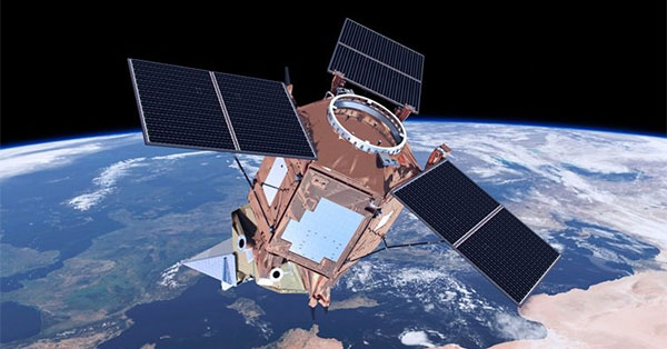
    CAP = politique agricole commune.

    The EU will launch a new satellite this week as part of the ‘Copernicus’ initiative. The earth observation programme has proved to be useful in dealing with natural disasters and its importance will grow to manage EU funds including the Common Agricultural Policy after 2020, director Philippe Brunet said.

    Philippe Brunet is director at the European Commission’s Directorate-General for Enterprise and Industry and is responsible for the Copernicus programme.

    ...
    In what recent crises was Copernicus used?
    The Copernicus Emergency Management Service (EMS) system is available to respond 24-hours per day, 365 days a year. In March, the EMS was activated for several floods in Greece, Croatia and Albania.
    In April, the Spanish Civil Protection Directorate General activated the EMS to produce delineation maps showing the extent of the flood over six areas. Copernicus EMS was also used for earthquakes in Italy, floods in Germany and Ireland and to monitor hurricane activity in the US in 2017.
    Thanks to this system, emergency managers, crisis responders and humanitarian actors all over the world have one more tool in their toolkit that can make their work more efficient and effective.
    Programme européen Copernicus (ex GMES). Satellites Sentinel - Page 3 H_52101199-800x600

    Humanitarian crisis management benefits from new technologies

    Weather alert systems, real-time communication and debit cards for refugees: the use of new technologies make humanitarian aid more effective, Commissioner Christos Stylianides said in an interview.  EURACTIV’s partner Euroefe reports.

    The new satellite launching this week will monitor ocean waste. The control of waste plastic is becoming a priority in the public agenda. How could this new satellite help reduce this waste?
    Detecting plastic waste in the ocean is difficult because it is either spread in little micro plastic particles or sinks under the water.
    Copernicus satellites can help in two ways. First, with ocean colour, we are able to observe the optical properties of waters, their transparency, turbidity, content in sediments and pollutants, such as phosphates, nitrates, iron, etc. Second, ocean waste affects the transparency and turbidity of water. Such observations give us a first indication of possible pollution that has to be checked with in situ observations if available.
    Sentinel 3B has three types of different sensors that enable the monitoring of the sea level, sea surface temperature and what we call the ocean colour, which helps to characterise the bio geochemical content of the ocean.
    Programme européen Copernicus (ex GMES). Satellites Sentinel - Page 3 5319414496_53d14ffa27_z

    EU mulls incentives for space technologies in farm controls

    The European Commission is considering new proposals to encourage the use of technologies to monitor farm parcels receiving subsidies from the Common Agricultural Policy (CAP), an EU official told EURACTIV.com.


    Copernicus could also be used to better manage the CAP. Could it increase the efficiency of EU funds? 
    Earth observation data is very helpful for the management and control of the CAP.  For many years, the data has been used by EU Member States to control farmers’ area aid declarations.
    The high-resolution images guide a new approach of the CAP “control”. CAP monitoring is expected to be significantly enhanced in the coming years and the Commission departments responsible for space and for agriculture are working closely together to strengthen their cooperation.
    The current discussion on CAP after 2020 includes new elements on environmental and climate targets, which are likely to lead to further demand for national and EU-wide performance indicators and reference baselines.
    Amongst others, crop rotation requirements, carbon sequestration measures, may be considered, each setting particular conditions to the type and manner in which performance indicators should be measured with the use of Copernicus high-resolution data.


    The UK plays an important role both in Copernicus and Galileo. The European Space Agency is in favour of maintaining British involved in both programmes. Are you in favour too?
    The Union’s space programmes are of vast economic, societal and security-related value to Europe. The UK will become a third-party country on 30 March 2019. The consequences for all EU policies are being assessed and discussed among the Commission and the 27 Member States in the context of their “Brexit preparedness” work.
    Indeed, now is the right time to start thinking about adjusting cooperation regarding the space programmes to the way the EU cooperates with other third countries in such matters.
    Programme européen Copernicus (ex GMES). Satellites Sentinel - Page 3 Ariane5_liftoff-800x600

    More space for more Europe

    2018 will be a crucial year to shape a stimulating new narrative for EU space policy. Jean-Loic Galle lists a couple of key points ahead of the 10th EU space policy conference taking place in Brussels on 23 and 24 January.

    The EU recently signed an agreement with India to exchange images. To what extent would this agreement make launching new satellites redundant?
    In March, we signed Copernicus cooperation arrangements with India and three more partners in Latin America: Chile, Brazil and Colombia. Similar agreements have already been signed with the US and Australia. We are also planning to sign with the African Union as well as key neighbourhood partners.
    Under these arrangements, the Commission will provide these countries with free, full and open access to Copernicus data. In return, the Commission will receive data from international partners’ satellites as well as regional observatory networks.
    These agreements are not only political signatures but also real cooperation commitments for the upcoming years which can benefit the EU and its partners. India as well as other new partners will facilitate the EU’s access to data from its regional observatory networks of geophysical and meteorological data.
    They will support the enhancement of the Copernicus data architecture and development of global products.
    Laurent Simon
    Laurent Simon
    Whisky Quebec


    Programme européen Copernicus (ex GMES). Satellites Sentinel - Page 3 Empty Re: Programme européen Copernicus (ex GMES). Satellites Sentinel

    Message par Laurent Simon Mer 18 Juil 2018 - 23:24

    https://www.telesatellite.com/actu/51841-satellite-optique-nouveau-contrat-pour-airbus.html
    Laurent Simon
    Laurent Simon
    Whisky Quebec


    Programme européen Copernicus (ex GMES). Satellites Sentinel - Page 3 Empty Re: Programme européen Copernicus (ex GMES). Satellites Sentinel

    Message par Laurent Simon Mar 24 Juil 2018 - 12:41

    https://www.euractiv.fr/section/climat/news/la-suede-appelle-leurope-a-laide-pour-lutter-contre-les-feux-de-forets/

    ... Stockholm a demandé l’aide de l’Union européenne car elle fait face à d’importants risques d’incendies.
    La Commission européenne a annoncé mardi 17 juillet la mobilisation de deux avions bombardiers d’eau depuis l’Italie dans le cadre du mécanisme de protection civile de l’UE.


    ...La Commission européenne a coordonné le déplacement de deux avions bombardiers d’eau depuis l’Italie. Cette aide se réalise dans le cadre du mécanisme européen de protection civile. C’est en fait la deuxième fois cet été que la Suède demande de l’aide en raison de graves incendies
    ...Le satellite européen Copernicus est également utilisé pour son système de cartographie d’urgence.
    Laurent Simon
    Laurent Simon
    Whisky Quebec


    Programme européen Copernicus (ex GMES). Satellites Sentinel - Page 3 Empty Re: Programme européen Copernicus (ex GMES). Satellites Sentinel

    Message par Laurent Simon Mer 22 Aoû 2018 - 19:20

    Je place ici un post, qui prolonge celui que j'ai mis sur le fil 'satellites environnement'

    https://france3-regions.francetvinfo.fr/occitanie/haute-garonne/toulouse/satellite-toulousain-aeolus-mesure-vents-sera-lance-ce-mercredi-soir-1529132.html

    "Ce sera le premier satellite qui mesurera les vents sur le globe terrestre depuis l'espace.  Il a été conçu dans le cadre du programme d'observation européen de la terre Copernicus. Jusqu'à présent, les vents étaient mesurés par des stations au sol, des bouées en mer, ou par des ballons-sonde ou des avions en altitude

    ... Aeolus fournira aux scientifiques et aux météorologues des mesures directes à intervalles réguliers. 

    "Il sondera l'atmosphère avec un laser puissant et devrait ainsi aider à mieux comprendre les dynamiques au niveau des tropiques et les processus influant sur la variabilité du climat, mais surtout à améliorer les prévisions météorologiques", précise l'Agence spatiale européenne."

    et d'autres precisions sur 

    https://www.usinenouvelle.com/article/l-esa-s-apprete-a-lancer-aeolus-le-satellite-d-airbus-pour-ameliorer-les-previsions-meteorologiques.N731924

    "Le satellite d' 1,35 tonne embarque un instrument LIDAR (pour LIght Detection And Ranging) baptisé Aladin. “Pour mesurer les vents depuis l’espace, Aeolus expérimentera une technique entièrement nouvelle basée sur un laser de forte puissance qui sondera les basses couches de l’atmosphère terrestre (jusqu’à 30 km d’altitude) afin de produire des profils verticaux des vents et de recueillir des informations sur les aérosols et les nuages”, explique l’ESA.
    À ce jour, l’observation des vents se fait grâce à des stations météorologiques, des ballons-sondes et d’autres satellites dédiés. À l’inverse de ces systèmes, Aeolus sera capable de fournir des données à des intervalles plus réguliers. Il apportera aussi des observation sur des portions du globe où les données manquent comme dans l’hémisphère sud et dans les zones tropicales.
    Les prévisions au-delà de cinq ou six jours seront ainsi nettement améliorées. Et le satellite permettra de modéliser des cartes dynamiques en 3D des vents terrestres sur toute la surface terrestre."

    et 
    https://www.ladepeche.fr/article/2018/08/21/2854709-aeolus-satellite-toulousain-mesure-vents-sera-lance-demain.html

    "toutes les données recueilles alimenteront en temps réel les grandes agences météo mondiales comme Météo France car la principale mission du satellite reste météorologique. Le vent a en effet été identifié par l’Organisation Météorologique Mondiale (OMM) comme une donnée essentielle dans l’amélioration des prévisions même s’il est encore difficile de chiffrer l’amélioration de la fiabilité des prévisions grâce à Aeolus.
    Si Aeolus permettra de dresser une carte précise des vents de la planète, le satellite doit aussi permettre de mieux renseigner les études climatiques et ainsi les modèles de climat. Le satellite gravitera autour de la Terre à une altitude de 400 km durant toute sa mission qui doit durer trois ans."
    Laurent Simon
    Laurent Simon
    Whisky Quebec


    Programme européen Copernicus (ex GMES). Satellites Sentinel - Page 3 Empty Re: Programme européen Copernicus (ex GMES). Satellites Sentinel

    Message par Laurent Simon Jeu 23 Aoû 2018 - 10:41

    Succès de la mise en orbite
    et contribution de technologies et de materiel suisses
    (oui l'Europe spatiale ne se limite pas à l'Union européenne)

    https://www.letemps.ch/sciences/mise-orbite-dun-satellite-europeen-mesurer-vents

    Contenu sponsorisé


    Programme européen Copernicus (ex GMES). Satellites Sentinel - Page 3 Empty Re: Programme européen Copernicus (ex GMES). Satellites Sentinel

    Message par Contenu sponsorisé


      La date/heure actuelle est Mer 8 Mai 2024 - 23:44