Laurent Simon a écrit:http://www.telesatellite.com/actu/45104-edrs-fournira-des-services-copernicus-en-cooperation-avec-la-commission-europeenne.html
un accord a été trouvé avec la Commission européenne (CE) concernant la fourniture de services EDRS au programme Copernicus de l'Union européenne
... Avec Copernicus et Columbus/ISS comme premiers clients de référence d'EDRS, Airbus DS peut investir dans l'achèvement et l'exploitation du système.
Le groupe devrait développer un marché commercial destiné à des missions de tiers et appuyer l'évolution du système pour qu'il parvienne à une couverture mondiale.
Les accords conclus permettent à l'ESA de renforcer son soutien à l'évolution d'EDRS engagée avec le programme GlobeNet lors de la session du Conseil au niveau ministériel de 2014.
A l'instar de la fibre optique sur Terre, EDRS l'autoroute spatiale de l'information permettra d'atteindre un débit de 1,8 Go /s grâce à des terminaux de communication laser.
Il assurera le transfert en temps quasi réel vers la Terre de données provenant de satellites d'observation de la Terre, de drones et de véhicules spatiaux via des satellites de télécoms géostationnaires.
L'ESA pourra recevoir plus rapidement et de façon plus sûre de plus gros volumes d'images ce qui améliorera la surveillance de l'environnement ainsi que la gestion des catastrophes et des crises
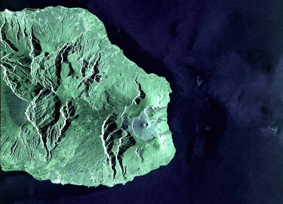
Voilà les premières applications, avec des images de l'Ile de
la Réunion ("
les autoroutes de l'information via l'espace ne sont donc plus de la science fiction" voir plus bas) :
First EDRS Laser Image From Copernicus Sentinel-1A
http://spaceref.com/earth/first-edrs-laser-image-from-copernicus-sentinel-1a.html

ESA today unveiled the first Sentinel-1 satellite images sent via the European Data Relay System's world-leading laser technology in high orbit.
The two images were taken by the radar on the Copernicus Sentinel-1A over La Reunion Island and its coastal area.
- The first was scanned in a
high-resolution mode,
- the second in a wide-swath mode that provides
broad coverage of surrounding waters, and used in particular
for maritime surveillance.
Sentinel-1A, sweeping around the globe at 28 000 km/h, transmitted the images to the EDRS-A node in geostationary orbit via a laser beam at 600 Mbit/s. The laser terminal is capable of working at 1.8 Gbit/s, allowing EDRS to relay up to 50 TB a day. EDRS immediately beamed the data down to Europe.
The transfer between the two satellites was fully automated: EDRS connected to Sentinel from more than 35 000 km away, locking on to the laser terminal and holding that link until transmission was completed.
... "With today's first link,
EDRS is close to becoming operational, providing services to the Copernicus Sentinel Satellites for the European Commission.
"EDRS is
the world's first laser relay service and features technologies developed by
European industry."
Volker Liebig, ESA Director of Earth Observation Programmes, stated: "
The Sentinels are the anchor customer of the new commercial EDRS service
and the Copernicus system wins new downlink flexibility. So
we have a real win-win situation."
"
SpaceDataHighway is no longer science fiction," noted Evert Dudok of Airbus Defence and Space. "It will revolutionise satellite communications, and help to keep Europe's space industry at the forefront of technology and innovative services."
"...
The SpaceDataHighway is a publicprivate partnership between ESA and Airbus Defence and Space. The DLR German Aerospace Center funded the development of the cutting-edge laser technology that forms the backbone of the system.
The first node, EDRS-A, was launched on 29 January 2016 as a hosted payload on the Eutelsat-9B satellite. The second, the dedicated EDRS-C satellite, will be launched in 2017.
The European Commission's Copernicus Sentinel satellites are the first users of the EDRS service.
ESA is planning the GlobeNet programme to extend EDRS by 2020, providing additional security services to satellites, aircraft and drones.
The laser communication technology used today will be able to bridge up to 75 000 km, sending data from one node
over the AsiaPacific region (EDRS-D) to another
over Europe (either EDRS-A or EDRS-C).
This global coverage will provide quasi-realtime services around the world linking instantaneously back to Europe."


